Stats: 5 miles one way to the lake. Approx 2 miles round trip from the lake to the peak. 1,100 feet of elevation gain from the lake.
Route: South ridge, steep class 2.
Gear notes: Good food and a new 4 person tent.
Lists of John: Peak 9863 on Lists of John
Idaho: A Climbing Guide by Tom Lopez. Peak 9863 (Bronco Peak)
 |
| Ian "I don't like my picture taken" Cox standing tall in front of Peak 9863, aka Bronco Peak. Note his choice of shirt. |
Around here, Father's Day means two things. First, it means absolutely nothing. I still work, cook, clean, mow the yard, etc, like any old day and I'm fine with that. Second, it means that I get to choose a hike and those who are present can't give no for an answer. I'm okay with that too. Last Father's Day was a bit of an epic. For this Father's Day, I decided to step up the game just a tad and do an overnight hike with a peak. Mountain climbing is only limited by two things; imagination and physical ability. Since my imagination is over active and my physical ability is, well, able, I needed to choose a hike that would be within reach of the whole gang. I was looking for a short hike to a lake for a camp and a short class 2 peak around 10,000ft.
Prairie Creek Peak caught my eye and seemed to fit the criteria, however, upon further research, I found a peak that had no ascents logged on Lists of John. I figured that a shorter peak and a possible first ascent seemed like a logical goal. And off we go!
Of course I was plagued by the vacation curse at work prior to this trip, just like always. After getting home on Saturday morning, I would have rather slept for about 6 hours, but there was adventure to be had. Working in EMS teaches you a few things; one of those is that functioning on 2 hours of sleep is normal, 10 hours of sleep over 3 days is fine and when you have a trip planned, don't waste time sleeping; there is time for that later. We had done a partial pack over the few days before, but still had a few loose ends to tie up. With the car packed and the check list complete, we headed out of town for our trip.
 |
| Trailhead #Selfie. |
We arrived at Prairie Creek Trailhead about 3:30. I did a less than stellar job of loading my pack and we just wanted to get going. Warm temps with the occasional breeze felt more like late summer.

I figured 5 miles to Prairie Lake, the sign indicated less. Another version of this story may or may not say it was longer. They can remember it how they want to; I'll remember how it really happened.
It was a 5 mile hike to the lake; yes it was up hill, that's all I will say. There was also some hum-bub about how long it would take. Geologic time includes now.
 |
| Ian leading the way. |
I remembered the trail to not be too steep as far as we went up it last year, from a climb here last August.
 |
| Looking west, up the canyon. |
Yes, the trail does go up hill and as usual, the hardest part is just before the lake. Deez would say I'm overly optimistic and she is probably right. But when I say "It's close" I mean it and I'm usually right. The effort required to reach the lake ended up being a bit more than I had wanted for Deez and Ian, but it really wasn't that bad. We were happy to reach the lake and found a really nice camp site at the south end.
 |
| Deez enjoying the views from near the outlet of Prairie Lake. |

The Smoky Mountains are short but rugged, comprised of highly fractured metamorphic rock.
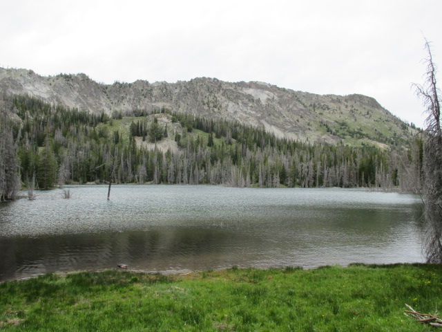
 |
| Prairie Lake. |
We hit camp in 2 and a half hours, pumped water from the inlet, set up the tent and got to work on dinner.

We are somewhat fanatical about eating well outside. For this trip, we did chicken quesadilla's. No dehydrated meal's. We prepped, planned and had super delicious food.
 |
| Deez approves of my concoction. |
If there had been other people at the lake, they would have been drooling.
 |
| Chicken Quesadilla's. |
 |
| The deer were quite comfortable with us chilling in there habitat. |
After dinner, we had a nice established fire pit at our camp site. Since we didn't bring dog, we had visitor's that we normally wouldn't have. They came in quite close. We laughed as they circled our camp several times. After a nice camp fire session, we called it a night. It was very warm throughout the night and into the next morning.

We didn't get up too early since we had a relatively short climb. Deez had made Banana Bread the day before we left and that's what we had for breakfast.

Our new 4 person tent was very roomy for 3.
 |
| Prairie Creek Peak. 10,138ft. |

Working our way up to the saddle wasn't too hard and we soon got a good look at our peak.
 |
| Castle Peak. |
 |
| Shadow Peak on the left. |
I finally got a decent view of Shadow Peak and Prairie Lake.

The west ridge of Peak 9863 didn't look too bad and our excitement grew more and more with each step we took.

From the saddle, the hiking was fairly pleasant and the obstacles were few.
 |
| The north point of 9863. |
There are two high points on the ridge and from the view below, the more prominent of the two appears to be the point to the north, but the north and south points are equal in elevation per my altimeter and GPS data. The USGS map also identifies the south point as the peak.
 |
| Prairie Creek Peak. |
I really wanted to hit Prairie Creek Peak, but I was not going to take Ian up it, and I was not about to leave him alone. It would have to wait for another day.
 |
| Looking up the West Ridge. |
There are goat trails that criss-cross the ridge. The steepest part is at the top where the occasional use of hands was needed to aid in balance through the fractured rock.
 |
| Ian getting his rest step on. Decent form, I'd say. |
I taught Ian all about rest stepping and pressure breathing. Slow and steady!
 |
| Nearing the top of the West Ridge. |
 |
| Nearing the summit, looking north. |
After the climb up the west ridge from the saddle, the route turns north to the summit.
 |
| The summit is in view in the trees. |
We saw goat poop and no signs of previous human occupation. The views off the ridge were awesome in every direction.
 |
| Pioneer Mountains. DBE is on the left. |
 |
| Summit view, looking south. |
Looking back on our route, it was easy to appreciate this beautiful area. I had told Ian that there is usually cell service up here and if there was, we would call Grandma to tell her where we were.
Ian: Hey, I have service!
Me: Haha, I told you. Put Grandma on speaker phone!
So that's what we did.
 |
| Summit view, looking west. |
We did plenty of looking around to make sure there was no trash, etc. There was nothing except the rocks, goat poop and Pika's. No goat's though, so that was kind of a bummer.
 |
| Summit view, looking north. |
A short journey to the north point revealed no signs of previous human occupation and an equal elevation to the south point. So we christened it Bronco Peak, and Gator Point.
 |
| The West Ridge from the summit. |
 |
| The North Point. |

Prairie Creek Peak looks steep and mean from this angle.
 |
| Norton Peak. |
 |
| Looking north. |
 |
| Prairie Lake. Looking northeast toward the Boulder and White Cloud Peaks. |
We Woo-hooed from the top and Deez later told us she could hear it. That's pretty cool!
 |
| Summit View, looking southwest. |
 |
| Looking north. |
Bronco Peak came from Ian's unwavering love of the Boise State Bronco's. Gator Point is from Denise's love of her home town team, the Florida Gator's. Keepin' the Blue and Orange alive!
I took a short video at the top.
 |
| Summit Selfie. |
 |
| Ian standing in front of the summit on descent. |
 |
| The summit of Peak 9863, aka Bronco Peak. |
We did not leave a cairn, register or summit marker of any kind. All we took was pictures; all we left was footprints.
 |
| Looking down the West Ridge to the saddle. The trail goes to the left. |
 |
| Ian actively trying not to smile. |
We joked and laughed our way down the ridge and back to camp.
 |
| Goat territory. |
 |
| Prairie Lake from camp. |
After some snacks and breaking camp, we settled on two things; The Wicked Spud for burgers and The Wrangler for milk shakes. Heck yes!
 |
| Looking down the trail. |
It was warm and monotonous work back down the trail to the car. We had had the lake to ourselves, but we pasted several day hikers going in and out.
 |
| Water break about a mile from the trailhead. |
It only took a couple of short breaks to keep the spirits and pace up.

My beer stash was just cold enough to drink while we changed clothes and re-sorted our gear.
The work was behind us and we were glad to be in the air conditioned car and heading for some grub. Peak 9863, aka Bronco Peak was a fun little peak and since we didn't see anything to suggest otherwise, I think we humbly made the first ascent.
 |
| Google Earth overview of the region. |
There was often discussion about sore feet, sore legs, this sucks, etc and I just answered with an old Ed Veisters quote. Pain is temporary; glory is forever.
Happy Trails!
- Granola, out.