Stats: Day 1: 4th of July trailhead to lower Chamberlain Lake camp. 4.3 miles, 3 hours via the Splattski Cutoff. Elevation gain/loss: 1,672/1,259. Day 2: Camp to Castle Peak. 2.3 miles round trip with 2,700ft gain to summit elevation 11,815ft. Time to summit; 3 hours, 5 hours round trip. Camp to 4th of July trailhead; approx 8 miles, 3hrs 19min via Chamberlain Basin trail.
Route: Southwest Gully class III/VI scramble.
Links: Castle Peak Summitpost page. Lists of John data for Castle Peak. Idaho: A Climbing Guide - Castle Peak. Chamberlain Basin Cross-Country Route aka the Spalttski Cutoff.
 |
| Castle Peaks South Face above Chamberlain Basin. |
Ever since I began researching and climbing mountains, something always drew me to Castle Peak. It's tall, steep and remote with little room for error. There is no shortage of of epic stories on this peak, including some recent rockfall involving serious injury. Scroll down though the log to read about it. Just getting to the base of this peak involves either an 8 mile hike or a steep scree filled chute known as the Splattski cutoff.
I had originally set dates to climb Castle last August and those got scrubbed due to poor weather. I finally had a window of time to attempt Castle Peak this year and even though I didn't have partners, I wasn't going to let this one slip by.
Walking the trail past 4th of July lake to Washington lake was pleasant but crowded. 2 miles, not much gain; down right easy. This was the first, only and last easy part of this trip.
 |
| The Splattski Cutoff is highlighted in red. |
 |
| Looking up the chute. |
Sticking to the right/south side provided some occasional solid holds. The middle was filled with assorted sized blocks just waiting to cut loose and break a leg, or worse.
 |
| Looking down the Chute to Washington Lake. |
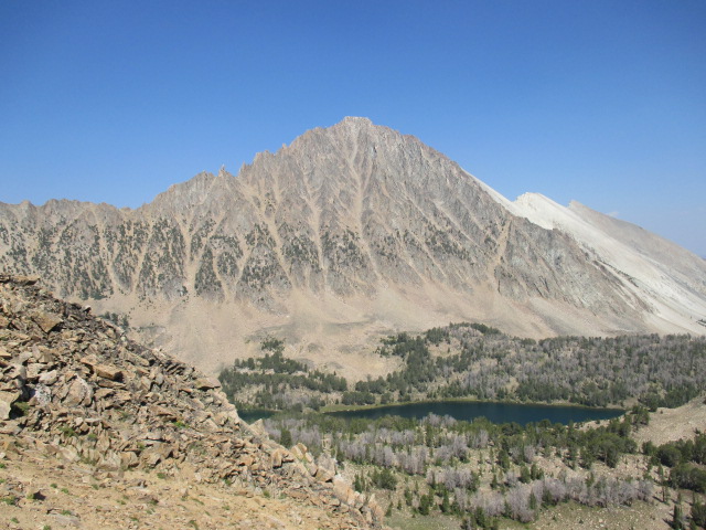
After clawing my way up the chute, I was smacked in the face by this tremendous view of Castle Peaks west face.
 |
| Castle Peaks west face. |
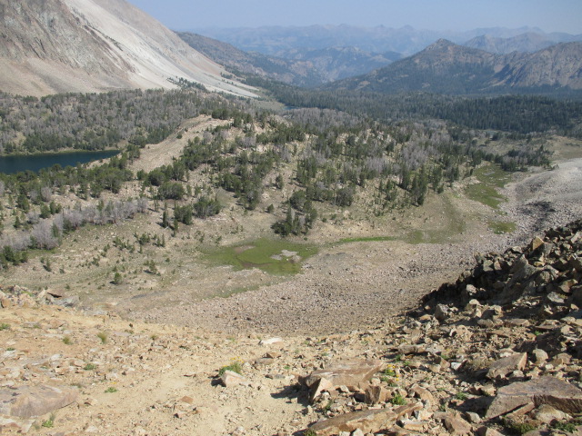
Looking down the chute into Chamberlian Basin, it appeared to be no small task to reach the lower lake where I planned to camp. Camping at the upper lake was an option but I wanted to be able to study the route prior to the climb.
 |
| Chamberlain Basin from the top of the chute. |
 |
| 4th of July Peak over Washington Lake. |
After dropping down into the basin I chose to take the long way around, walking between the two upper most lakes. It was easy to appreciate the beauty of this area and even more so after the effort required to get there.
 |
| Serrated ridge over the middle lake. |
 |
| Castle Peak from camp. |
I arrived at the lower lake (9197) in about 3 hours and had the place to myself for the time being. I had the view I wanted from my camp. I sat and studied the face for a good long while. Not too long after I arrived, two other parties arrived. Both were in their last night of backpacking the White Clouds loop.
The night cooled off rapidly and I liked what I heard; silence. No audible rockfall from the imposing peak was a good sign.
 |
| Southwest gully route close up. |
I was up at 7:00am the next morning and fumbling with my equipment in the cold wind and set off about 8:30. The first move of the climb was to reach the tree covered slope in the lower right corner of the above picture. From there, the route follows the obvious gully and climbs the buttress just to the right of the small snow patch.
 |
| Looking up form low on the route. |
The scree slope required to get to the trees, was, well, scree.
Steep, loose... I'm beginning to see a pattern forming.
 |
| Lower Chamberlain lake. |
Haze from the wildfires had settled in the dense atmosphere of the morning.
 |
| Looking up the gully. |
The lower gully wasn't too tough. Just the routine focus was required to make solid foot placements and keep an efficient stride. The last 300 feet or so is near vertical rock in places. Class III/IV, good holds and really fun. There is not much in the way of exposure, but the occasional loose blocks were enough of a reminder to stay focused.
 |
| Granola for scale. |
I can't attest to being on what would be considered the standard route. I think its more just a matter of picking a line that one feels comfortable with.
 |
| Excellent scrambling. |
The lines I took were though several of these V shaped dihedrals. They were steep but very good climbing making for quick time up the peak.
 |
| Furry friends at over 11,000ft. |
While stopping for the occasional micro-break, I noticed this little guy checking me out, just hanging out at over 11,000 feet. He was very curious, probably trying to distinguish between a solid technique and desperate moves by a clumsy human.
 |
| Feathered friends at over 11,000ft. |
This bird was also quite interested and apparently unfazed by my presence.
So, after passing that small snow patch, the gully becomes very narrow with blocks that looked like a Jenga game had been played by the Mountain Gods. Big blocks of questionable stability toppled over that I would not recommend climbing though. From here I traversed right as I climbed up, trying to make sure to not cliff myself out.
After another 50 feet or so of sustained scrambling, the angle eased back and the summit came into view.
 |
| Upper talus slope to the summit. |
There were cairns marking a path, but they originated from a different area, further to the right, than I had came up from.
 |
| Hazy summit view, looking northwest. |
Unfortunately, the haze obscured the view of the Sawtooth Range to the west.
 |
| Summit shot with WCP;s in the background. |
Short video from the summit.
 |
| Furry friend on the summit. |
At this point, I think my summit company was more interested in my food than anything.
Sorry bro, can't share with you.
 |
| Looking north to the WCP's. |
Several lakes are visible from the highest point in the White Clouds. I lost count in the upper teens and I'm sure there were many that I couldn't see because of the haze.
Its ironic; I have seen Castle Peak from so many other surrounding peaks and now that I was on top of Castle, I couldn't see the other peaks.
 |
| WCP's close up. |
After a near continuous 3 hour climb to the summit, I took most of my rest on top. I was still a bit on edge and a little nervous as I started the descent. I tried to reverse the same route, but there were a few areas that I didn't recognize.
As long as I can see down it, its all good!
 |
| Down climbing. |
Down climbing the upper route was just as fun as going up. I made a few more airy moves to spice it up a bit.
 |
| Looking down the lower gully. |
With the fun part over, it was back into the loose talus. More frustrating than anything, but there is no way around it.
 |
| Wildflowers. |
The wildflowers were still out and showing off their colors. As usual, the picture has nothing on the real thing.
I arrived back in camp at about 2:30. I had been waiting to decide on which escape route I would take until now. I was faced with the either/or philosophy. Either I was going to claw my way up and down the steep chutes in hopes of cutting off some time and miles, or I was going to take the more mellow but longer trail out and just try to make good time. I elected to defer the laborious tedium of the scree chutes and take the trail. After all, this was my first trip into this area. Why not order the full meal deal!
 |
| Castle Peak from trail #109. |
The views of Castle Peak from the south were enough to make me forget that I was faced with eight long miles back to the car.
 |
| This view cannot be over appreciated. |
This area is very impressive and I'm glad I finally got the chance to visit. The mountain Gods were kind to me on this trip and I probably took a sizable withdraw out of the Karma National Bank.
Gotta keep makin' those deposits!
 |
| 4th of July Lake. |
Hiking out on late afternoon on Monday meant light traffic and a good opportunity to take some pictures at 4th of July Lake. Something I didn't have on the hike in.
Those final miles just melted together and I arrived back at my car in just over 3 hours. I was sore and more or less depleted of those semi-important things like glucose, water and electrolytes.
A 6 year old goal is now complete. I wouldn't say it was a dream come true, I just decided to go.
 |
| Google Earth overview of my route. |
Flying solo on this trip was not my first choice, but sometimes that's how it's going to be.
You can either fight the tiger, or you can dance with the tiger. The choice is yours.
Happy trails!
- Granola, out.
Amazing feat and great post. Thanks for making your trip reports so detailed. It makes me want to get out and try some of them. Castle Peak is way beyond my skill level though! Keep up the blog posts.
ReplyDeleteThanks for reading!
DeleteAwesome!! I enjoyed your post! I plan on hiking Castle tomorrow morning with a buddy of mine if all plans out this morning. Sounds like we wont be disappointed, thanks for posting such good info!
ReplyDelete