A long and winding journey comes to an end in a two day peak-athon.
Date: August 4, 2017.
Objective: Diamond Peak 12,197ft. Lemhi Range highpoint, 4th highest peak in Idaho, 1 of 3 ultra prominence peaks in Idaho (5,000+ft), 2nd most prominent peak in the state.
Stats: Strava track 8.4 miles and 5,100ft gain in 8hrs round trip.
Partners: Josh S.
Gear notes: N/A.
My climbs of the 12'ers in order of ascent: 2010 Hyndman Peak. 2011 Borah Peak. 2012 Mount Idaho. 2013 Lost River Peak (personal favorite). 2013 Mount Breitenbach. 2014 Leatherman Peak. 2015 Donaldson Peak, first attempt on Mt. Church. 2016 Climb of the north face on Mt. Church. 2017 Diamond Peak, 2nd ascent of Donaldson, official summit of Mt. Church and finish.
GoPro video
Seven years ago I embarked on the Journey of climbing the nine peaks in Idaho that exceed 12,000 feet in elevation. I've had the pleasure of climbing with some really great people on these challenging peaks. I've had a few people ask me; which one is the hardest? My answer; they're all hard, they just have different personalities, different kinds of hard. I've also had a few people ask; how do you climb a mountain like that? My answer; one step at a time.
Josh and I had talked about teaming up for Diamond since the spring outing. We nailed down a date and decided it made since to also hit the Lost River Range since we'd be in the neighborhood. I needed to officiate my 12'ers finish and finally get to the true summit of Mount Church. We headed out of town in the afternoon for the drive over to the Birch Creek valley to make camp at the base of Diamond Peak. The road was passable to within about a half mile of the peak. It was hot and smoky with no shade and plenty of bugs. We sipped beers and chatted into the evening as the sun went down, all the while eyeing Diamonds famous east ridge we would climb in the morning.
 |
| Diamond Peak in the afternoon haze. |
We were up before the sun and quickly broke camp to get moving in the cool morning air.
 |
| Heading up the lower slopes to Diamonds famous east ridge. |
There were cows low on the route but they kept their distance and didn't give us much trouble. We kept an eye on them, just in case.
 |
| Lower slopes. |
 |
| First break. |
It was smoky enough that by now I had a weird taste in the back of my throat that was enough to make me gag a couple times, but other than that, we cruised right along. But that's easy to do at Josh's pace.
 |
| Start of the scramble. |
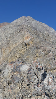
Soon we found ourselves at the base of the upper ridge and all that stood between us and the summit was another 2,000 feet.
 |
| Upper east ridge. |
 |
| Climbers trail heading up. |
 |
| Crux of the est ridge. |
We followed the ridge, looking for the weaknesses through the crux to sneak our way up. It was definitely class 3, solid and fun.
 |
| Climbing though the crux. |
 |
| Climbing though the crux. |
Some of the more exposed sections required close examination but for the most part the route was pretty intuitive.
 |
| Final pitch to the top. |
After the crux, the final section to the summit was mostly class 2 and if I dare say, easy.
 |
| Summit. |
The summit had a slight breeze and very hazy views waiting for us. We could see Bell Mountain and The Riddler, but not Borah or a single peak in the Lost River Range. It was Josh's first Idaho 12'er and my unofficial last. We had a nice break and some snacks with the whole mountain all to ourselves.
360 summit video
 |
| Summit cairn. |
 |
| View north to Bell Mountain. |
 |
| View south looking over The Riddler. |
 |
| Josh with the flag. |
 |
| Summit flag. |
 |
| Climbers log. |
Down climbing the ridge was pretty fun and other than me getting slightly off route, went by pretty quick.
 |
| Josh hanging ten on the descent. |
 |
| Walk of shame back to the car. |
We descended into the heat of the afternoon and headed straight for the car with only a couple of very short stops. It never felt so good to be 99% done with something, but we weren't headed home quite yet. We headed over to Mackay to get into position for part 2.
No comments:
Post a Comment