Stats: 6 mile round trip. 6 hours total time. Time to summit 3:45. Elevation gain: 2,900ft.
Route: Southwest Ridge, class 2.
Gear notes: Used snow shoes on the escape. Crampons and ice ax used on the final 600ft to the south summit.
Gladiator Peak Summitpost page. Avalanche advisory for the day of this climb.
 |
| Gladiator Peak. 10,243ft. The southwest ridge is seen from the left, to point 9,607 to the summit. |
Gladiator Peak sits just east of Galena summit, close to highway 75 and offers good early season access. I've been eyeing several peaks in this area for some time, and now that I felt ready to attempt a bigger peak, Gladiator won the top spot on the list. It's been six months since I've done anything at higher altitude, not to mention above 10,000ft. I was flying solo for this trip and woke up at 4am, was on the road just before 5, arriving at a pull-out just south of Galena Summit at 8:30.
The temperature read 27*F at the car, so I anticipated a solid overnight freeze to the snow pack; good news. However, the day was forecast to be about 20*F above normal; potentially bad news. Clear skies, no wind.
My planned route was to cross the highway and head east though the forest staying at about the 7,600ft contour line, hop over a small unnamed stream and then cross Westernhome Gulch. Starting out across the flat area, the snow was fairly firm, so I didn't bother with snow shoes, however, the occasional post-hole was making its dreaded guest appearance. Down in the trees, there was nothing to take pictures of, except trees; so no pictures.
 |
| Looking south from the base of the ridge. |
Once across Westernhome Gulch, the next move was to turn north, hike uphill while looking for a Forest Service road that runs along the base of the southwest ridge of Gladiator Peak at about 7,800ft.
I had actually found the correct ridge with little difficulty.
Hu, now I actually have to climb this mountain!
From that point on the route up the southwest ridge is fairly steep and the south facing slope was mostly snow free down low. Now I was faced with an 1,800ft climb to reach point 9,607. I was thinking about dropping my snowshoes to lighten the load, but I didn't want to be stuck without them up higher in case I needed them. There was nothing to do but continue up and re-evaluate as I gained elevation.
Sometimes it's better to have it not need it, than need it and not have it...
 |
| Titus Ridge in the Smoky Mountains. |
The hard work up the ridge was soon rewarded with views of the neighboring peaks in the Smoky Mountains.
 |
| Negotiating the alternating snow and dry ground up the steep southwest ridge. |
It was moderately frustrating carrying snow shoes when the ground was bare; but I knew that wouldn't last. I hit continuous snow at about 8,600ft and it was still fairly firm, yet not without the occasional post-hole. It was about 10:30 and I wanted to top out by noon, 1pm at the absolute latest. The day was getting notably warmer and I needed to get moving. After a short break and evaluating all conditions and factors, I decided to drop the snow shoes and make a run for it.
 |
| Consistent snow above 8,700ft en route to point 9,607 dead-ahead. The summit is behind the tree on the right. Old ski tracks are visible. |
I was thinking about how soft the snow would be on the way down. Even though it was easy walking now, I knew that might not be the case later in the day. I wanted to get the upper most parts of the ridge finished before it became too soft and unsafe, so I just kept moving without any breaks. From that point on, the angle eased off and I was able to make good time.
 |
| The upper ridge and final 600 feet of Gladiator Peak from point 9,607. |
Arriving at point 9,607 I was treated to this magnificent view of the upper ridge. It looked manageable, as long as the snow was firm. Keeping to climbers right (east), I rounded 9,607 only to find that it was probably corniced to the left (west) and drifted about 20 feet deep or so. I didn't bother to stick my neck out and examine.
Oh, that's nice!
This brings up this point; spring is a great time to climb when the conditions are right. Cool temps and firm snow often make for good climbing. Its what may or may not be under the snow that was concerning to me at this point. Had I known that 9,607 was in the shape that it was in at that time, I probably would have not climbed over it. But, now that I was already on the other side of it, I decided to give the last 600 feet a go. I'd take it one step at a time and as soon as it seemed like the snow was getting too soft, I'd back off.
 |
| Looking back at point 9,607. |
 |
| Looking south down the Wood River Valley. |
Just before the upper ridge kicked back, I strapped into my crampons and grabbed the ice ax. Sticking to the shaded areas provided the best snow and the climbing was pleasant. I was about half way up the ridge when I punched through a drift up to my thigh.
Holy crap, not cool!
 |
| Wet slide activity on the west face. |
Wet slide activity was noted and appeared to be coming from the rock band at the top of this couloir. I wondered if I should have been backing off at this point, but I was right below the final scree slope that appeared to lead to the summit, so I went after it.
 |
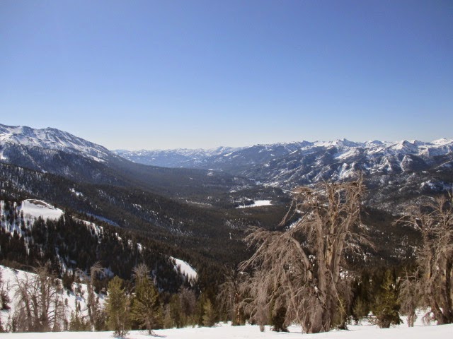
| Looking southwest toward the Smoky Mountains, Galena Summit and the southern edge of the Sawtooth Range. The entire southwest ridge is visible. |
I popped off the spikes, dropped the ax and got to work on the scree and short class 3 scramble. Looking at the topo map, the south summit and north summit are on the same contour, but I had read that the north summit has the cairn and is apparently higher, so that's where I planned to go. Once on top of the south summit, I could see that the cairn, if even still there was completely buried by a huge drift that was likely a hanging cornice. I stayed focused as I poked around and got as high as I safely could, but I had a gut feeling that I was about to get into serious trouble if I went any higher. No way was I going out onto, or underneath this sucker.
 |
| Looking northwest from the base of the drift/cornice that covered the summit. |
This is about fun and adventure and I need/want to be safe because I want to keep having fun and going on adventures.
 |
| Looking west toward the Sawtooth Range. |
Normally, this would be a happy time filled with smiles and sandwiches. Not that I wasn't happy, but my nerves were a little fried. It was noon-thirty by the time I snapped a few photos and got to work on the descent.
 |
| Looking east toward Galena Peak. |
 |
| Looking south down the valley toward the Smoky Mountains. |
 |
| Not a cloud in the sky. |
Getting back to 9,607 in itself wasn't a huge deal but I could tell the snow was getting soft. At least I was back to the mellow terrain and who doesn't mind a few post-holes anyway, right? Wrong! I thought about traversing under 9,607 to avoid the drift/cornice but abandoned that idea when when I dropped to the east and started punching down about knee deep. I worked around a few trees just about to my original path and once there I went in about thigh deep again.
Holy s***! Seriously not cool!
This about sums up how I felt.
I dug out and took one more just like that. I was about to lay out and crab-crawl to the trees but I made it without having to look like a total idiot. After a gulp of water and a short spell of SVT I was able to regain my composure to continue the descent.
 |
| Titus, Bromaghin and Saviers Peaks. |
The snow on the road was total slush without a solid step to be had without snow shoes. No big deal here, it's just that there were a few long sections that were melted down to the dirt.
I'd rather walk with snow shoes on dirt than take another post hole, and I'm definitely not playing the on again-off again game!
 |
| Pretty sure I'm doing it wrong here. |
I passed both creeks, dropped off the road and angled toward the highway, which was just a short walk away. As I shed my gear, I realized that out of the 6 hours I'd been out, I had been moving for about 5:30 of it. I'd been so intent on getting up, down and out that I never really stopped or ate more than a Rice Crispy treat and one pack of Cliff Shot Bloks. Oh, and by now it was 60*F when I got back to the car at 2:45pm.
Hey, I'm ready for that sandwich now!
So, for now I'll leave the asterix attached to this summit, but I'm officially claiming it, sort of, and here's why: I worked my ass off to get up it and it's not like I bailed 300 feet from the top because I was tired. The north summit was buried and it just wasn't safe to walk out there. Just to clear this up, I plan to go back sometime later in the year and hike it from Galena Lodge just in case the north summit is actually higher. I now realize that I didn't get a picture of that drift across the ridge.
While the day had been a little nerve racking at times, it was still fun and I was glad to have done it. Based on my observations during this climb, I think I'll wait until a more consistent freeze-thaw cycle settles in to attempt another big peak if done with snow on the route.
For such a relatively short day, this was a tough climb. It still leaves me feeling just a tad frustrated. Maybe I pushed it too much; maybe not enough.
One thing I still know; pizza and cold beer is a tried and true recovery aid.
Happy trails!
-Granola, out.
Nice write up. Fun read! I tried Gladiator last year about this time and ran into snow I could swim in. I took the Galena Lodge route you mentioned. I couldn't get any higher because the snow and angle kept me sliding back down anytime I took a step up. I turned around just to be safe. Heard/saw avalanches that day. Take care!
ReplyDeleteRF, thanks for reading. Glad you made it down safe! The peak will still be there when you decide to go back. ;)
ReplyDeleteCheers!