Stats: 4 miles, 500ft and 2hrs 30min round trip. Approached from the Corral Creek jeep road intending to get all three peaks.
Squaw Butte North 5,626 (not attained). Squaw Butte Middle 5,896. Squaw Butte South 5,540.
Gear Notes: N/A.
Squaw Butte, middle peak 5,896.
We had wanted to get out and do a hike at the last minute so I picked Squaw Butte. There are actually three peaks along the ridge that I wanted to hit. I've been to the south peak, but the middle peak is the highest and the north peak is a ways away and the lowest. I had intended to do my homework for this hike but a busy schedule had left me without a printed map or a real good idea of the terrain. We set out to hike all three peaks anyways.
Pfft, what-ev's, we don't really need a map.
Looking west.
We drove to within a half mile of the end of the road at the radio towers and headed to what we thought was the middle peak. I have been up the east side twice and had not been up this side before.
Radio Towers.
The day was breezy and cool and we figured we were in for some rain.
Squaw Butte Middle 5,896.
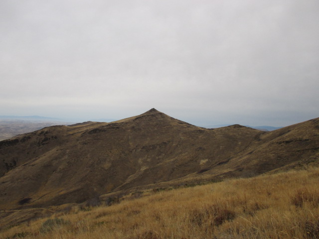
I kept eyeing this point and thought it was the north peak; it turned out I was wrong. It was the middle peak. It looked cool and I wanted to stand on it anyways.
Squaw Butte Middle 5,896.
It had been a little more than 4 years since I've been up here I thought the south peak was behind us, and that we would pick that one up on the way back.
Deez topping out on Squaw Butte South.
I had remembered going to this point before and I always thought it was the highest Squaw Butte. As I later figured out, this was the south point that sits a whopping two feet lower.
Squaw Butte South.
It still made peak #1 of the day.
Squaw Butte Middle. The north point is the small bump to the right it.
Deez didn't want to go for the next one, so I broke off and ran for it.
Squaw Butte Middle,
There is a lot of bushwhacking and a short scramble to reach the top.
Looking north, across the peak.
Peak #2 went by quickly and I got back to where Deez was waiting and we set off towards the radio towers, where I thought the south peak was.
Squaw Butte South.
On the way back, I realized something was amiss. I had not done enough mileage to have reached the north peak. It was getting late and the north peak would have to wait for another day. D'oh!
Marker near the radio Towers.
We found the marker that I always thought was the south peak and walked around the radio towers.
Looking south.
Despite the overcast sky, we never got more than a drop or three of rain.
Looking north. Middle Peak is on the right.
I didn't get a good picture of the north peak; probably because I thought I was on it at the time. That's why it always pays to do the homework. According to my calculations, going to the north peak should have been about a 7 mile round trip.
Mount Church on the left, Donaldson Peak on the right.
Donaldson Peak, 12,023 feet tall is Idaho's 8th highest and is officially named after the late chief of the Idaho Supreme Court, Charles R Donaldson. Mount Church, 12,200+ is Idaho's 3rd highest and unofficially named after the late Idaho senator Frank Church. These two peaks are often combined together in the same climb since they sit on the same ridge line. Dan Paulson had contacted me and told me of a request he had received from the Donaldson family to carry some ashes of some family members to the summit of Donaldson Peak. Out of respect for the family, I will keep those details to a minimum. We planned to get some pictures and video of the memorial on the summit to give to the family.
The three of us met up in Mackay and then caravanned to camp at the end of Lone Cedar Road. We used the North Fork Jones Creek approach. The road isn't in too bad of shape but flat ground to pitch a tent is scarce thing. Dan has been to the top of both of these peaks several times, Brent was looking to complete his quest of the 12ers and I was looking for peaks seven and eight of the coveted nine above twelve.
Sunset from camp.
The sunset was easy to appreciate as we chatted a bit before turning in. We planned a wake up time of 4am and wanted to set off by 5. The next morning was clear and oddly warm.
Starting up the scree.
Hiking up the North Fork of Jones Creek by head lamp was a treat in itself. It was a case of bliss in ignorance. We couldn't see anything so we had no idea how far up the canyon we were until the sun started to rise. We were at the head of the canyon and starting up the scree at about 7am.
Sunrise on the Pioneer Mountains.
We estimated that we had covered 2 miles and 2,000ft at this point. We climbed up the scree into a series of Tarns. Two of the three were dry, but the uppermost still held a small amount of water.
Approaching the tarns.
We got to the uppermost tarn where we took a short break to eat, adjust layers and don helmets for the climb up the head wall between the two peaks.
Upper tarn looking at the head wall.
This head wall is classic Lost River Class 3 crap. It is extremely difficult to not dislodge rock and care must be taken when going through it.
Head wall.
The head wall looks quite imposing from the basin, but there is a doable route. It was noticeably cooler and it didn't take long after stopping that we started to get cold.
A little chilly.
This tarn sits about at 10,800 feet and we stashed our trekking poles next to the large rock since they wouldn't be needed higher up.
Climbing the head wall.
We got to work up the talus and were soon negotiating the ledges and chutes of the head wall.
Pack left behind by someone.
We found an old pack and one trekking pole that appeared to have been there for a while. It was a puzzling find and there was no identifying information found.
Dan and Brent climbing.
Dan and Brent climbed first and I tried to hang back where I would be out of the way of rock fall.
We did the climb in sections and once we were in it, the route was obvious.
Working up a ledge.
One piece after another, the puzzle of the head wall came together. The difficulty of the climb up was increased by the loose rock, otherwise it could be a rather enjoyable scramble.
I had ducked under a couple ledges while Dan and Brent ascended which made for good opportunities to take a few pictures.
Strata on Church.
The depositional strata of the Lost River Range was once a sea floor, meaning at one time, this was below mean sea level. These rocks are Devonian in age dating back about 380my.
More ledges.
Ledges and chutes were the name of the game. The walls of the ledges revealed fossils; a lot of them.
I had my eye on the rocks in the wall and not on the ones above me and that's when it came. A couple blocks large enough to smash a couple fingers and had they hit my head without a helmet, it would have been game over.
We knew there was moderate wind in the weather forecast and we could hear it whipping across the ridge above us.
Brent and Dan discussing the route.
The above photo shows what is probably the steepest section of the head wall.
Climbing the rock rib out of the head wall.
Once we turned this last corner, we could see the final chute to the saddle. We climbed a rock rib to get off the loose stuff and soon found ourselves on the saddle and in some seriously cold wind.
Climbing a rock rib out of the head wall. Dan Paulson photo.
We took a short time to adjust our clothing to suite individual needs in the wind and then headed for the summit of Donaldson Peak.
Mount Church.
From this point on the ridge, it was only a short section of mostly class 2 to the top.
Dan and Brent climbing to the summit of Donaldson Peak.
We topped out on Donaldson and were pleased to find the wind was fairly calm here.
Summit.
We each had a short celebration of our own. This was Dan's 6th time up here, Brent got his 8th 12er and this made 7 for me.
Looking east.
The view was grand, as always.
Looking west at the route up Mount Church.
We scoped the ridge to Mount Church and hoped the wind would die down.
Dan signed us in the summit register and we got to work on the memorial duties that were requested. Dan gave a good speech that we recorded. My eyes were welling up.
7 down, 2 to go.
We got packed up and headed back down to the saddle to climb the ridge up to Mount Church.
Down climbing Donaldson.
There was a bit of snow in the shaded north facing aspects, but not enough to detour around and it certainly didn't require an ice ax or crampons.
Working around a ledge en route to Church.
We worked around the obstacles on the ridge with increased effort due to the wind.
Climbing the ridge to Church.
There is some exposure to deal with, but nothing too bad. The class 3 scrambles should have been enjoyable, but the wind made it hard work.
Just before we turned back.
We made it to the last notch in the ridge where we discussed conditions and our options. Physically, we felt fine. The route was manageable but we had the most difficult and exposed section before us to get to the summit of Mount Church.
The last 500 vertical feet of Mount Church.
We were 500 vertical feet below the top but we had sustained wind of maybe 40mph or greater and gusts beyond that. The exposure coupled with the strong wind didn't add up to a safe climb. We decided that climbing to the summit of Mount Church was to great of a risk for us to take.
"Safety first, fun second, success third." - Edmund Viesturs.
If you're not safe, you have no business being there. If you're not having fun, you're doing something wrong. If you can get to the top; great, but it has to be a round trip. The summit is only the halfway point.
Donaldson Peak.
We still had to reverse our moves on the ridge to get back on route to descend the head wall and we had plenty of time in which to do it. We made sure to take in the hard earned view.
Taking a break on the ridge.
It's my opinion that any ridge walk is a good one and this was one of the best.
Pahsimeroi Valley.
Looking into the Pahsimeroi Valley is always a treat.
Descending the ridge. Dan Paulson photo.
It was a cold and windy battle back to the descent route and there were still some obstacles to overcome.
Descending.
We had marked the specific notch in the ridge that we needed to descend. Pick the wrong one and that might spell disaster.
Mount Church.
We had stopped in the notch before the final pitch to the summit in the above photo.
Now the focus was on the slipping and sliding descent down the series of chutes and ledges to get back to the tarn below.
Pelvic bone.
We found some bones near the base of the head wall, still pretty high up in elevation.
Back at the upper tarn.
Back down at the tarn it was warm and mostly out of the wind. We had a nice break and adjusted layers once again for the increasing temperatures we would have on the way down.
Approximated route.
Dan picked up the pack and trekking pole to carry down.
Williams Peak.
We slugged out the scree and broke out on a few long slides where we could.
Dan and Brent hiking down.
We made our way down to the grass to give our feet a break from the rock and continued down at a leisurely pace. We started early, so we got done early.
Donaldson Peak.
The descent got hotter as we hiked out, but we figured it was a fair trade to be out of the howling wind on the ridge.
Hiking down.
The transition from scree to grass was a welcomed one.
Back into the canyon.
On the way up in the dark, we did an okay job of staying on the trail. On the way down, we followed it all the way back to camp.
Frogs Head.
Dan picked out this feature on the canyon wall and we called it the Frogs Head. It think the name should stick.
Old cabin remains.
We passed the remnants of on old cabin down in the creek.
Hiking out.
We distracted ourselves from the rough hike out with conversation and then we hit the sign of salvation; sage brush, and soon we were back in camp. In the end, it was still a peach of day.
I have no problem turning around when the conditions are bad; this isn't do or die. All it means is I get to go climbing with my buddies again. In this case, it also means that I have to go back up this head wall, which I silently told myself I didn't want to do. It's either that, or a snow climb up the north face of Mount Church next spring.
We had a goal beyond our personal pursuits and completing that was the real success. That and going home, of course.
"Getting to the top is optional, getting down is mandatory." - Edmund Viesturs.