A long, hot and smoke filled day to the high point of the Sawtooth Range.
Date: August 13, 2013.
Partners: N/A
Stats: Approx 14 miles in 8 hours round trip with approx 3,000ft of gain to summit elevation 10,751. Class 2, one short section of class 3 via the south couloir route.
Gear Notes: A black shirt was a bad color option on this hot day.
Links:
Thompson Peak on Summitpost.
Idahosummits trip report.
Thompson Peak on Idaho: A Climbing Guide.
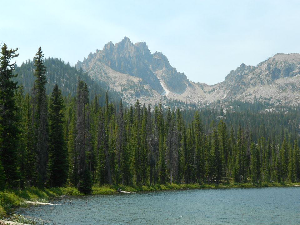
Thompson Peak is an incredible climb. My plan A for Thompson was to hike in and spend the night at lake 9,000 to break it up into two shorter sections, as opposed to one really long day. When I ended up at Redfish lake with my family for a few days, I felt I should go for it with plan B: one very long day. The Halstead fire was burning and the smoke had settled in thick the on the morning that I started out. It was August so I figured it would get pretty warm during the day, and it did.
 |
| Sawtooth Mountains. |
The early stages of this hike from the Redfish trail head is quite popular as a day hike and horseback ride. There were only a couple other hardy souls on the trail when I started out just before 8am. I knew I was in for a long day so I really had to make a conscious effort to not move too quick early in the day and burn up my energy. It's about 7 miles just to the top of the peak.
 |
| Sawtooth Mountains. |
I hit the wilderness boundary, signed in kept at it. I was looking for an unsigned climbers trail that leaves the Fish Hook trail and heads to lake 9,000.
 |
| This sign always makes me happy. |
 |
| Peak 10,300 from the trail. |
 |
| Haze over the Sawtooth Valley. |
After finding the unsigned but obvious climbers trail it was steep going up to the lake. I got my first up close and imposing view of Thompson Peak.
 |
| Thompson Peak. |
 |
| Looking down the climbers trail. |
 |
| Looking up the climbers trail. |
On the way to lake 9,000, the views really open up and I cannot stress the beauty of this area enough. If you've never been, you are truly missing out. I believe that some people refer to this as "Profile Lake."
 |
| Thompson Peak behind lake 9,000. |
 |
| Serrated ridge above the lake. |
I pulled into a fine spot on the shore of lake 9,000. The water was crystal clear and I could count the fish as I fueled up for the push up to the saddle.
 |
| Lake 9,000. |
 |
| Thompson Peak. |
In my humble but honest opinion, these are some of the finest views in the Sawtooth Range.
 |
| Thompson Peak from the saddle. |
Just reaching the lake is reward enough, but I had my sights set a bit higher (pun intended).
The talus hopping and boulder dodging on the way up to the saddle wasn't too bad, but definitely used up some energy.
It was hard work to get to, not to mention up the saddle. The view from there to Thompson was as awesome as it was disheartening. Thompson was still a long ways away, I was beginning to feel my energy attenuating and I had less than 2 hours before my turn around time of 1pm.
 |
| Valley behind Thompson. |
The way to the south couloir was a mixed bag of treats; talus hopping and snowfield crossing. There was no real trail, although there were a few rock cairns. I just picked the most direct path with the least resistance. In other words, my route meandered a tad.
 |
| Looking down the lower couloir. |
Once in the couloir, the route becomes steep but manageable class 2 up to a notch where you turn climbers left and climb the last 15 feet or so of class 3 with some exposure to the true summit.
 |
| Lake 9,000 from Thompson Peak. |
The view from the top did not disappoint. My advise is to not go too close to the edge to see what is over there. Don't worry, there is nothing for about 2,000 feet until the rocks above the lake.
 |
| Summit Register. |
I found the Mazama's register placed in 1961.
 |
| Goat Benchmark. |
I found the Goat Benchmark.
 |
| Summit. |
 |
| Its good to know this is up there. |
I found the emergency helo-evac fund. The clock was ticking so that meant that I had to get going.
 |
| South couloir and summit block. |
These are more comprehensive views of the south couloir and summit block.
 |
| Looking down class 2/3. |
I heard voices just around the right corner. It was a group of three about to summit.
 |
| Note the large rock slide over the snow. |
The day was really heating up and I could hear rockfall nearby.
 |
| Mount Regan. |
The views are everything one would expect from a range highpoint.
 |
| Mickeys Spire from Thompson. |
Mickeys Spire looked like a complex scramble.
 |
| A less impressive view of Thompson from the valley behind it. |
 |
| Looking down the valley. Note the large plume of smoke. |
Moving back to the saddle went pretty smooth and I could really notice the smoke in the air.
 |
| Mount Carter. |
There is a very doable route from Thompson Peak to Mount Carter, which I would have included if I had done plan A.
I had told Deez to meet me back at the trail head at 5. She had gone out on a horseback ride and I was still high on the mountain and without any way to let her know I might be a few minutes late. All I could do was put the rubber to the road, err, dirt, and get the heck out of there. Now there were quite a few people out on the trail, including Deez and our newly acquired spaz-O-matic dog just a few minutes from the parking lot. It was a few minutes past 5 and we were on our way back to camp for steaks and cold drinks.
High mileage and warm temps meant lots of sweating and losing those important things called electrolytes. Not only did I get the highest summit in the Sawtooth Range, but I also got some bad leg and foot cramps.
The next day of our time at Redfish was looming; I had promised Deez we'd hike to Bench Lakes with RayO and the dogs.
Day 2 - Hike to Bench Lake.