Date: June 1-2, 2021.
Team: Todd and Roy.
Objective: Mt. Rainier 14,410.
This was to be maybe one of our last trips together. Todd would be leaving on his mission to Africa soon. Since we couldn't go to Rainier last year, we figured we'd better try now while we could. Our secondary original plan for this trip was to climb Mt. Baker a few days before we tried Rainier. There was a significant storm that hit the PNW which made Baker out of the question for us. Since we had to bail on the first leg of the trip, it did allow us to spend more time on Rainier and get a feel for conditions.
Word on the trail was that the storm had left a 6ft wind slab at around 13,000ft and was turning everyone around. I noticed that after the storm, there was a significant warming trend. At first, I figured the warming trend would help to stabilize the slab, but alas the heat proved to be our nemesis. Not exactly the problem you'd expect to have on Rainer in early June.
Day 1.
We drove to Mineral, Washington where we set up camp in a packed campground. Holiday weekend and all. No on hill action today.
Day 2. Strava
Drive up to Paradise and get on the hill. We weren't super late, but we weren't early. It was already plenty warm when we set out at 1030. Since we didn't get our warm up peak, we needed to go over some skills and make sure we were all on the same page when it came to such matters as roped travel, someone falling in a crack, etc. The heat was brutal and we ended up cutting our day short. The ski back to the parking lot was, well, hot and miserable. At least it wasn't far.
 |
| Packing up in the parking lot. |
 |
| Getting ready. |
 |
| Roy heading up. |
 |
| Lower route. |
 |
| Heading up. |
 |
| Todd enjoying the views. |
 |
| Mt. St Helen's. |
Day 3. Strava
Tag Camp Muir. Since we didn't get our warm up peak, we needed some acclimatization. Lucky for us we had the perfect hill for it. This also allowed us to get familiar with the lower mountain. The route was fairly straight forward and pretty much what Roy and I remembered. There was a high overcast that rolled in and spared our carcasses from baking in the heat. We felt strong but we were still hearing not great reports on the upper mountain. The skiing was okay but the temps were still way too warm. We felt super lucky to at least have the views that are often times obscured this time of year.
Back in camp, Todd made us a traditional South African dish, Mealie Meal Chakalaka (I hope that's correct). It was really cool to hear about his native country and help him prepare and eat a dish that had a lot of sentimental value to him. Todd, we're going to miss you buddy!
 |
| Skinning up above Panorama Point. |
 |
| Crossing a short section of dirt. |
 |
| Me, Roy and Todd on the Muir Snowfield. |
 |
| Camp Muir at the top of the Muir Snowfield. |
 |
| Todd skinning up. |
 |
| Mt. Adams. |
 |
| Getting close to Camp Muir, but still not that close. |
 |
| Camp Muir. |
 |
| Looking across the Cowlitz Glacier. |
 |
| One hearty meal, indeed. |
Day 4.
Rest day. We hung around camp and took it easy. Recent reports had indicated that teams were summiting; good news. One thing that did catch my eye were the forecasted super warm temps and associated freezing level. Normally, you'd want it nice and high, like maybe 13,500ft or so. The freezing level was above that two days before our summit attempt and was forecast to continue to rise. Most of my tension and worries were fading, but now I had a whole new set of problems to worry about. Our game plan was to play it super safe and cautious, but go until something turned us around or until it no longer made sense to continue.
Day 5. Strava
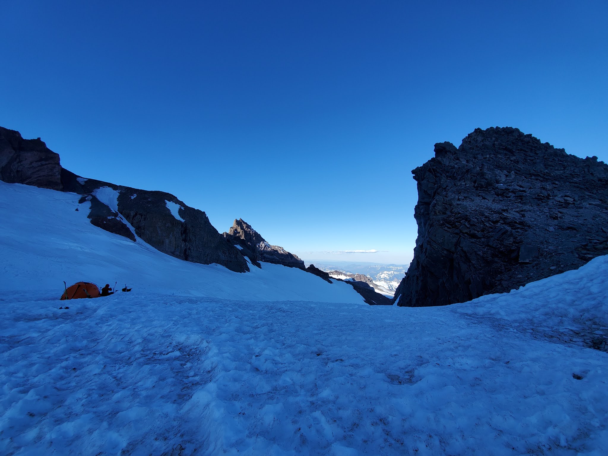
Hike to Camp Muir. These were the days we had our permits for, so we were heading up. We knew it was going to be a very warm day. After attaining the physical permit, we loaded our packs and headed up. The weather forecast over the next 36 hours was interesting: freezing level at 15,500 with temps above freezing on the summit but clear skies and light wind. With all this heat comes increased overhead and underfoot hazards. This was the first big thaw that this mountain had seen, and there was recent load to the snowpack to consider. We heard varying reports on conditions of the upper mountain (upper mountain meaning above Camp Muir). Someone/ some team had experienced a minor crevasse fall. We did make good time up to Muir, considering the heavy packs and brutal heat.
At Muir, we went about our duties of getting the tent up and secure, getting snow melted for water and getting organized for our summit attempt. Even as the sun set, it never really felt cold. I think we hit the hay around 1900 and set alarms for 2230 with the planed departure time of 0000. As per normal cold weather procedure, I slept with everything I'd wear in the morning either on my person, or in my sleeping bag. Admittedly, I was slightly overdressed and it was pretty warm in a zero degree sleeping bag.
 |
| Team photo just prior to departure for Camp Muir. |
 |
| Walking out of Paradise. |
 |
| Todd on the Muir Snowfield. |
 |
| Our site at camp Muir. |
 |
| Sunset. |
 |
| Roy glissading down from Panorama Point. |
 |
| The last camp fire of the trip. |
Day 6.
Summit attempt. We were up and comfortably hanging around outside the tent under a starry sky. No gloves, no beanie's, just and extra layer to keep the chill off. It was almost uncomfortably warm as we started moving. I was in the lead as we set off on the traverse of the Cowlitz Glacier. The snow was slushy and sloppy which made for lousy footing, even with crampons on. About 20 minutes out of camp as we approached Cathedral Gap, we stopped dead in our tracks and listened in awe to the sound of what I would call significant rockfall just in front of us. I could see the headlamps of a small team up near the top of the gap, but I couldn't see any rockfall. It took a minute for it to stop and just at the very moment we started climbing again, there was another round of rockfall not as large as the first, but somewhere in front of us. There was no way to tell where it came from or where the path of the debris was. Whether or not the rockfall was human caused that triggered a bigger slide, or natural rockfall due to the warm temps I cannot say. All I know is that it was much bigger than what I would consider safe. If it was "this warm" now and stuff was already coming down at midnight, what would the conditions be 12 hours from now? The best call for our us at that time was to play it safe and retreat. There were a couple teams still heading up who said they heard the rockfall from even further away, but I guess it didn't spook them like it did me.
Discretion is the better part of valor and I've got nothing to prove. It did not make sense to keep going in the face of questionable conditions. If Rainier was 2 hours way, I probably wouldn't have even went for a summit attempt at this time given how warm it was. Or if I had the luxury of climbing here more often and had a better feel for conditions, I might have had more information to evaluate this situation differently. Turning around was the call and rule number one of turning around is don't regret it. We got back to camp, unroped and hung out for a minute, then just back to bed. Slightly bummed? Yes. Disappointed? Not in the least. Climbing peaks like these is always a crap shoot, but you have to roll the dice to play the game.
So, one interesting thing to point out. We were just about to rope up and head out when Roy called out that he'd need to go see a man about a horse real quick. If he hadn't and/ or if we would have headed out sooner, would we have been even closer to, or possibly in the line of fire of the rockfall? Speculation sets in...
We were in our usual high spirits as we headed back down the Muir Snowfield later that morning. The snow was very soft and I for one was glad we didn't ski with heavy packs. That would have sucked! It would have sucked even worse to get hit by falling rocks, though. It was a quick and uneventful descent with a few rocket-like glissades thrown in.
It was still an awesome trip with two fantastic guys. Hopefully it won't be our last together. Hopefully it wont be so long until the next time I get back here.