Ascent date: June 3-4, 2016
Partners: Cody, Jim and Lerch.
Stats: 50 degree Snow climb, 4,300ft gain to 12,180ft and 9 miles in 22hrs round trip but didn't get the true summit.
Gear notes: Overnight bivy kit - approx 25lb packs.
Links: Summit attained in 2017. Summitpost page. Lists of John. Cody's GoPro footage.
 |
| Jim in front of Mt. Church. |
Cody, Jim and I put together a climb up the north face of Idaho's third highest mountain. 12.200ft tall Mount Church is normally climbed from the west side and approached from highway 93. Cody and Jim wanted a ski descent so the north face was the logical choice for them and I've been eyeing this route for a long time myself. The drive to the Pashimori side is longer and significanly more rough than the highway making this route very remote. We saw a few people on the drive in and out, but had the mountain all to ourselves.
 |
| Lerch. Note: Cody is getting in the front-left passenger seat. Jim is in the drivers seat on the right. |
Cody and I met Jim and his rig Lerch in Banks and set off on the long drive. Lerch is a trailhead finding beast of a machine with quite the back story. He was the superhero of the trip as Jim piloted us into the very rugged but amazingly beautiful Pashimori Valley. We ran into a guy from Virginia who reported he had attempted Mt. Corruption, only to be stopped short of the summit due to soft snow at about 11am.
 |
| Pashimori Valley. |
 |
| Pashimori Valley. |
 |
| Pashimori Valley, |
 |
| Heading out. |
We hopped across the east fork and followed the trail for a short time before heading off-trail into the canyon.
 |
| Approaching the trail. |
Jim and Cody carried skis so they did a majority of the route finding down low as we wandered and bushwhacked through the canyon.
 |
| Mt. Church. |
Seeing the north face with my own eyes for the first time struck me pretty hard. Its very big and imposing to say the least.
 |
| Creek crossing. |
First thing was next, find the bivy spot. We were able to find our landmarks and picked our way up the canyon without too much trouble. Then we saw this tall and beautiful waterfall that we were on the wrong side of. We hiked the scree and snow fields to the right and crossed above it where the river originates as a spring from the hillside.
 |
| Water fall. |
 |
| Upper valley. |
Once we got across the water hazard and above the treeline, the going was pretty smooth, but the hour was growing late. We needed a bivy site and preferably before dark.
 |
| Note the crack in the upper snow field. |
This side of the Lost River Range has a wonderful alpine feel to it. The upper valley here is just spectacular.
 |
| Approaching camp. |
Jim was below Cody and I when we came across a meadow with running water and was the first into our unplanned Shangri-La bivy site. We decided to hold up here and climb the rest in the morning
 |
| Bivy. |
 |
| Sunrise. |
The overnight temps never felt too low as I laid in my bivy sack while drifting in and out of consciousness. We were up at 04:30, fueled up, loaded our packs and were going an hour later.
Hmm, it's kinda warm for snow climbing...
 |
| Mt. Church. |
We were less than impressed with the snow as we started out. The quantity was there, just not the quality. I was on snow shoes moving up the unsuportive snow with some difficulty while Jim and Cody skinned up with what appeared to be relative ease.
 |
| Route up the north face. |
We passed the lake that we had originally planned to bivy at. It was open and there was enough flat ground to camp. We all had to shed a layer pretty quick in the warm morning temps. The name of the game became top out by ten, done by one. We got a move on. The ledge's on the face lay cattywampus and with the soft and lousy snow, we chose the main snowfield to the left to avoid exposure to the cliffs that cross the fall line, in case of a slip and being unable to self arrest.
 |
| Jim and Cody skinning up the headwall. |
Skinning up looked to be going well for Cody and Jim. I was sinking in to the boot top level with snow shoes on. Fun times. We could see a lot of recent wet slide activity as we worked up the headwall.
 |
| Old avy track. |
We regrouped and applied crampons to climb up some old avy debris hoping it would be firm. It was not. The lack of supportive snow made for tough going and a suspision that we might not get too high before needing to bail.
 |
| Low on the north face. |
We soldiered on taking only short maintenance breaks and taking turns breaking trail. We did see old ski and boot tracks in the snow.
 |
| Jim starting his lead. |
The higher you go on the route, the more the angle increases.
 |
| Break time. |
It was 8am and already t-shirt weather with a slight breeze.
 |
| Jim at a rest break. |
After Jim's lead, he and I had a short break while Cody pushed on.
 |
| Cody finishing his lead. |
We caught up to Cody while he rested and then I took the lead for the last 1,400ft or so to the top of the north face. It was a difficult lead in the ever softening snow. I fought for every step.
Step, sink, stab, stab. Step, sink, stab, stab. Step, sink, stab, stab. Step, sink, stab, stab.
We estimated the upper slopes to be 50-plus degrees as we four pointed our way up. Once on top we saw the knife edge summit ridge was corniced and we couldn't go any farther. Perspective of the ridge was hard to tell but our summit was very airy with bearly enough room for the three of us. We did the typical well that point might be higher, yada-yada for about thirty seconds of the two minutes we spent on top.
 |
| All smiles on the top of the north face. |
A few pictures and few sips of water was about all we had time for. It was 9:30 and we needed to get down ASAP.
 |
| High point. |
Looks like we missed the actual highpoint by just a bit. My altimeter logged 12,180 which was probably off a bit one way or the other. I think Codys GPS said 12,155...? I suppose it was a near miss but we were elated that we climbed the north face. Jim and Cody felt it was close enough and I would agree, the high point was a technicality. I guess I'd say that we summited but did not hit the high point. The peak bagger in me still feels only 99.9% satsified.
Oh well, sometimes that's all you get!
 |
| Looking north towards Borah Peak. |
I was more concerned with being stable on our small perch in the sky than I was with photos or high points. In hindsight, I'm a little disappointed I didn't get more photos of the gnarly ridge.
 |
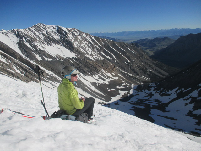
| 12k mildly hypoixic grin. |
 |
| Jim enjoying the views. |
We had the Idaho Summits Spring Outing group in our thoughts and hoped they were doing well as we gazed at the Pioneer Mountains. I started down while Cody and Jim clicked into their skis. They were well past me in no time and I struggled my way down. Normally, plunge stepping isn't that bad, but it's hard to do when you sink in up to your knees with every step.
 |
| Arch at the base of Mt. Church. |
We regrouped at the bottom of the face and refueled once more before heading back to camp.
 |
| Lake 9682. |
 |
| Cody and Jim heading down. |
We broke camp and were heading down about a quarter past noon. Not bad, but we still had the off trail descent to do with full packs. It was slow going at times but we found a good route down the canyon and back to Lerch.
 |
| Mt. Church from the trail. |
I will say that this trip had it all: It was remote with a moderately difficult cross-country approach, a cool bivy site, alpine start, crappy snow, difficult steep face to an airy summit with no time to spare on the route and with great partners who had PMA all the way. Per Cody and Jim, this was Type II fun; hard and kinda hate it while you're doing it, but remebered as fun in retrospect.
Adventure level was 10/10 and we were all smiles as we headed back to civilization with Jim at the helm of Lerch for the long and bumpy drive out of the Pashimori Valley. This trip is easily on my favorite list.
Happy trails!
No comments:
Post a Comment