A climb of Mt. Whitney via the Mountaineer's Route was a long but beautiful day.
Date: June 26, 2018.
Partners: Mark.
Objective:
Mount Whitney 14,494.
Stats: Approx 18 miles and 6,300 feet of gain. High point of the contiguous U.S. and California state high point.
Strava track. Note - GPS signal bounced off of the canyon walls at the Ebersbacher Ledges and added mileage.
Gear notes: Carried ice ax and crampons and multiple layers. Actually used the ax to climb one short section of snow. Carried 3.5 liters of water which was barely enough.
Links: The
Whitney Zone Forum is an invaluable resource for information on Mt. Whitney.
Summit Post.
After
White Mountain Peak, we had a rest day in Lone Pine. Mark got some work done at a coffee shop while I took advantage of the last couple of hours of cell service to go over route info and quadruple check the weather. I learned a valuable lesson when we picked up the permit. Apparently you have to re-confirm your permit two weeks before your entry date after you've already won it though the lottery and accepted and paid for it. Well, I didn't know that. The ranger dude was cool about it and said its not a problem and happens all the time.
"Yeah, its in the fine print, way down on the bottom of the confirmation letter" he said. Seriously bro! Something like that should be in the freaking subject line!
Anyways, we did not have a problem other than my heart skipping a few beats. We got our permits and wag-bags and headed up to the trail head camp ground perplexed by the confusing and tedious nature of getting a permit for Whitney.
Between social media, the Whitney Zone Forum and talking to the ranger and a couple of people in a gear shop, we had zero recent beta on the Mountaineer's Route, specifically the Final 400, the crux of the route.
Maybe no news is good news. We planned for the worst and hoped for the best. It is worth mentioning that the Mountaineer's Route is not a maintained trail, but it is a more direct route to the summit than the main Whitney Trail which is rated class 1. The Mountaineer's Route is a hard cross-country hike and class 3 climbing at the crux. Most people take the Whitney Trail.
 |
| Mt. Whitney from the Portal road. |
 |
| Sorting gear. |
 |
| Trail head. |
There was some confusion over the location of the camp ground, but if you drive around enough like we did, you'll eventually find it. The small tent sites are walk-in, which which is kind of a pain in the you-know-where, but not the end of the world.
We decided on a 2:30am wake up and to hit the trail as soon as we were ready. I figured we would finish the climb in 12-14 hours under optimal conditions, with 14 being the most likely scenario.
Bed time came quick with such an early start, but that's nothing new. I used to have a really hard time sleeping before an alpine start, but over the last couple of years it's gotten better. Whether its a long trail run or big climb, I try to put my mind at rest by telling myself-
you've done everything you could do to prepare. Your backpack is ready. Just relax.
The alarm sounded at 2:30am and as I quietly sat up to get changed I felt a super charge of stoke that helped to offset my usual grogginess. We left the tents, grabbed the food from the bear box and ate breakfast while we slurped down some strong coffee and tied our boots. It already felt crazy warm.
Less than an hour later we were hiking up the trail. Not long after starting we came to the turn off for the North Fork of Lone Pine Creek, the approach to the Mountaineer's Route. Everyone else we saw was taking the main trail.
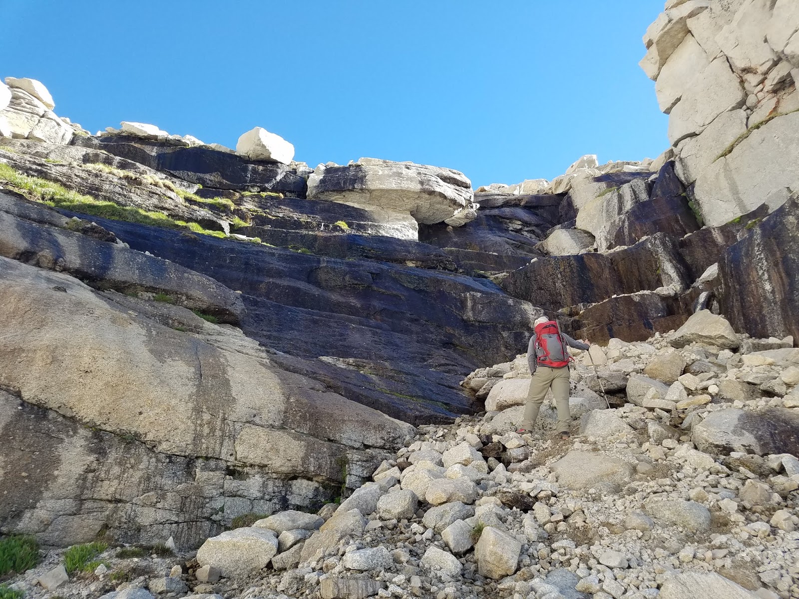
After about an hour of hiking up the creek we hit the base of the Ebersbacher Ledges; the first of the days problems to be solved. The sun was just barely coming up but navigating it by head lamp was really not that hard.
 |
| Mark on the Ledges. |
 |
| After the Ledges and below Lower Boy Scout Lake. |
From the end of the Ledges to Lower Boy Scout lake was fairly straight forward. LBSL is more like a marsh and there were a lot of mosquito's. We had a short break before pushing on to Upper Boy Scout Lake; the next problem to be solved. There was a trail down low, but as we worked our way up to the talus slope and boulders, we ended up going a bit too high. This required us to hike down a shallow creek/waterfall, then bushwhack a bit to regain the trail. That burned a bit of time but nothing serious. We had picked up a stupid amount of trash.
Come one people!
 |
| The route to UBSL. Whitney in the background. |
 |
| Looking north across the valley. |
 |
| LBSL. |
 |
Cool snow formation.
|
Hiking to UBSL provided a great view of Whitney and the Needles next to it. After a quick pit stop we pushed on to Ice Burg Lake. This was steep and rocky but there was a decent trail with cairns to follow.
 |
| Mt. Whitney on the right and the Needles to the left. |
 |
| Climbing a wet cliff to Ice Burg Lake. |
 |
| Pointing to The Notch. |
 |
| Mark standing next to Ice Burg Lake. |
From Ice Burg lake there is a class 2/3 scramble to get to The Notch, which is the last checkpoint before climbing the Final 400. It was steep but on mostly stable rock, The altitude started to slow us down a bit. Mark had forgotten his helmet and he couldn't exactly go back and get it. We did our best to space out and make careful moves. There was one short section of slushy snow with hard water ice under it that we used our ax's to get over. After that it was clear all the way to The Notch. We passed a guided group that was roped up.
 |
| Enroute to The Notch. |
 |
| Mark climbing some fun class 3 rock. |
 |
| Above 13,500 and almost to The Notch. |
 |
| Mt. Russel. |
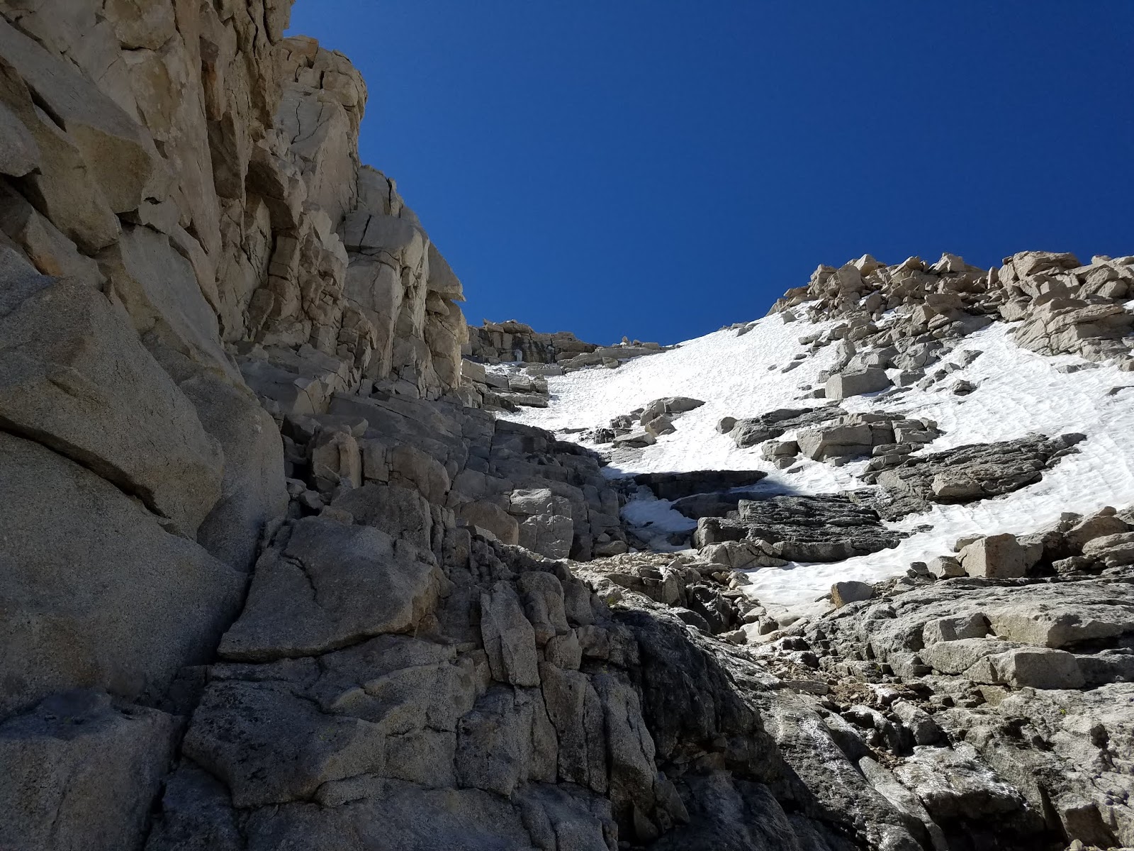
The Final 400 is a steep gully that leads to the summit plateau. We had a mix of rock and ice that looked a bit tricky but doable. We discussed using the rocks on the right, but I had suggested to climb the left side. That got us pretty high, but then we were a bit stuck. The snow was too steep and hard to traverse and we hadn't yet seen an obvious route up the rock.
We analogized this to a football game. It was 4th and goal with inches to the goal line and we'd just fumbled the ball and put a tie game on the line.
 |
| View west from The Notch. |
 |
| The "easy" walk-off traverse. |
 |
| The Final 400. |
 |
| Mark climbing up the final 400. |
We discussed our options which included down climbing, then traversing over and climbing the rocks on the right, where the guided group was. I had thought about climbing the snow but it seemed too icy for how steep it was. We had poked around on the rocks to the left and above us prior to this point, but no obvious route stood out. As we prepared to back down, I gave it one more go. One move revealed the next. This blocky/cliffy area was not too exposed but it might have been class 4+, with a big move or two. We progressed higher and higher. The climbing was very focused. We stopped for a brief moment and looked at each other. We silently knew that we were one move away from finding out if we blew the game or got the ball back and scored the winning touch down.
Mark looked over the last block and shouted "it's flat, I can see the shelter!"
 |
| Summit shelter. |
The big game had come down to a field goal. The kickers legs were tired but the kick was good.
 |
| Mark on the summit. |
 |
| Summit. |
 |
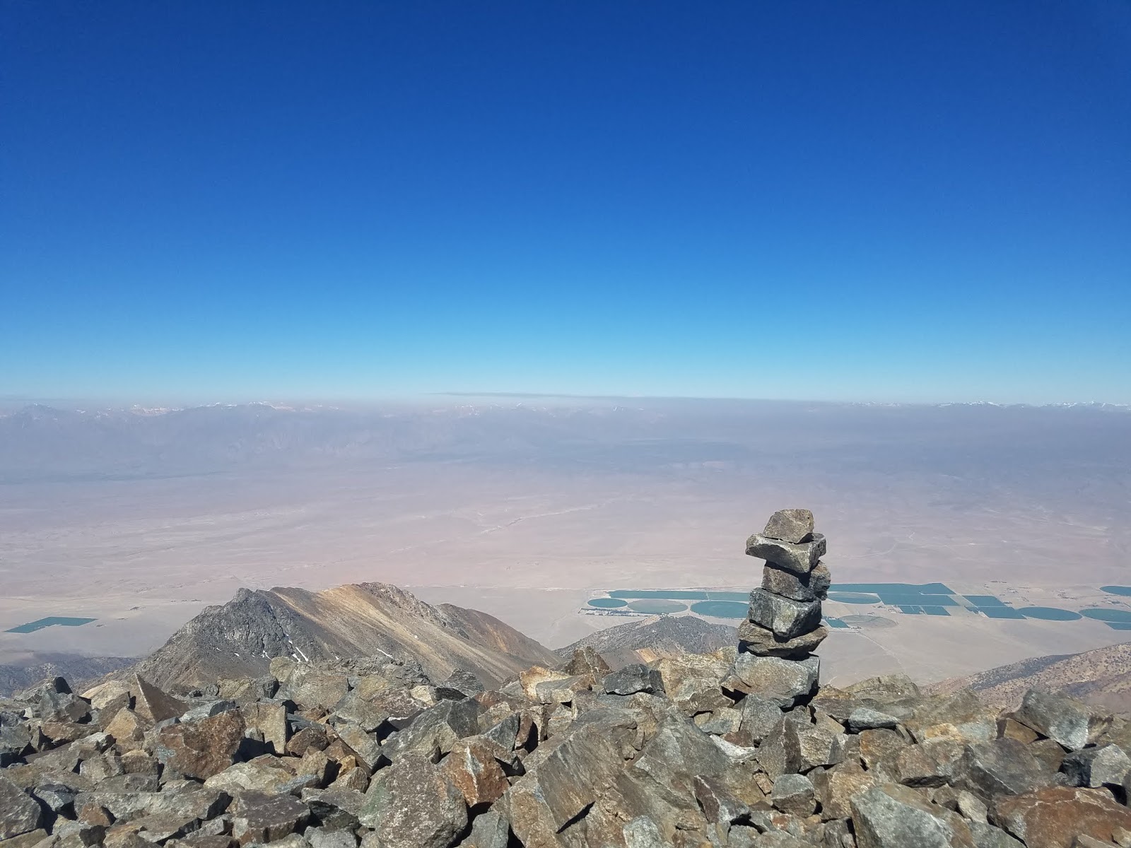
| Looking west from the summit. |
 |
| USGS benchmark. |
 |
| Summit shelter. |
We got some funny looks from all the people up on the summit since we'd come up from the opposite direction of the trail. There were a lot of people in fact, but we weren't too surprised. There was a guy flying a drone, and, uh, yeah, I gave it the finger. Two in fact. Come on man!
 |
| Looking south from the summit. |
 |
| One more hard earned selfie. |
 |
| Sierra's. |
We were a bit behind the time we thought we would make in getting to the summit, but sometimes that's how it goes. It felt nice to take a break but we had a very long hike down the main trail ahead of us, so we packed up and got going.
There were a lot of people still headed up; too late in my opinion, but my opinion is just that.
We jumped in the line of people heading down the main trail for the 11 miles and 6,300ft descent with the intent of tagging Mt. Muir, another 14er, along the way. Not an easy descent by any means.
 |
| Mark on the summit plateau. |
 |
| Lakes on the west side. |
 |
| Trail Crest. |
 |
| So many lakes. |
 |
| Mark hiking down the switch backs. |
Step after step we pounded the trail down. We chatted with a fellow who told us where the route up Mt, Muir was, then dropped our packs and went for it. We apparently missed the route and there was no way we were going to tag the next summit. We were looking a very tall, near vertical route and decided that today was not the day. We dropped back down to our packs and ducked under some rocks for some shade and a short break.
It had been a tough and very warm day and we still had almost 9 miles to go. We got to work on the famed 99 switchbacks of the main trail. They were really not that bad; short and never too steep. The Cables section had a small amount of snow and word had been passed along that it was tricky, but it was easily passed.
 |
| The Cables section. |
 |
| Wotans Throne. |
 |
| More switchbacks. |
99 switchbacks... it felt more like 472. The main trail is super cool but we were wearing down. The only relief we had from the heat was a small front that brought in some scattered clouds and a light breeze. It seemed like forever before we got below treeline and into some real shade. Mark and I are no strangers to high mileage days. We knew Whitney would be tough and this was one tough day, no doubt about that.
Super Troopers quote's kept our spirits high.
 |
| Grinding out the last few miles. |
We had a quick stop so Mark could refill his water, but beyond that, it was a non-stop return trip. If I had been able to find a comfortable position, I would had dozed off during that stop. Neither of us had eaten since we started down the switchbacks.
 |
| Looking down the main trail, nowhere near the trail head. |
 |
| Balance beams. |
At least the main trail did not require route finding. All we had to do was keep moving. Maybe that was easier said than done, but we did it.
 |
| Wilderness Boundary. |
 |
| Cactus. |
We rejoined the point where we left the main trail so that meant we were close to the trail head. In the light of day we were able to see what our headlamps did not illuminate 15 hours ago. Having to pack up the little bit of camp we had left felt like insult to injury. It might have taken forever but I had thrown out the concept of time. At some point before dark we had made it back to Lone Pine and checked into the Hostel. After we cleaned up and called our gal's, I do remember it being 8:30pm because I saw the Pizza Factory closed at 9. The bread sticks, pizza and a pitcher of Sierra Nevada Pale Ale was pure bliss.
Littering and...? Littering and...? Littering