Tuesday, June 23, 2015

Annual Father's Day Hike. Possible First Ascent of Peak 9863 aka Bronco Peak. June 20-21, 2015.

Partners: Deez and Ian (has yet to adopt a trail name).

Stats: 5 miles one way to the lake. Approx 2 miles round trip from the lake to the peak. 1,100 feet of elevation gain from the lake.

Route: South ridge, steep class 2.

Gear notes: Good food and a new 4 person tent.

Lists of John: Peak 9863 on Lists of John

Idaho: A Climbing Guide by Tom Lopez. Peak 9863 (Bronco Peak)

Ian "I don't like my picture taken" Cox standing tall in front of Peak 9863, aka Bronco Peak.  Note his choice of shirt.

Around here, Father's Day means two things.  First, it means absolutely nothing.  I still work, cook, clean, mow the yard, etc, like any old day and I'm fine with that.  Second, it means that I get to choose a hike and those who are present can't give no for an answer.  I'm okay with that too.  Last Father's Day was a bit of an epic.  For this Father's Day, I decided to step up the game just a tad and do an overnight hike with a peak.  Mountain climbing is only limited by two things; imagination and physical ability.  Since my imagination is over active and my physical ability is, well, able, I needed to choose a hike that would be within reach of the whole gang.  I was looking for a short hike to a lake for a camp and a short class 2 peak around 10,000ft.

Prairie Creek Peak caught my eye and seemed to fit the criteria, however, upon further research, I found a peak that had no ascents logged on Lists of John.  I figured that a shorter peak and a possible first ascent seemed like a logical goal.  And off we go!

Of course I was plagued by the vacation curse at work prior to this trip, just like always.  After getting home on Saturday morning, I would have rather slept for about 6 hours, but there was adventure to be had. Working in EMS teaches you a few things; one of those is that functioning on 2 hours of sleep is normal, 10 hours of sleep over 3 days is fine and when you have a trip planned, don't waste time sleeping; there is time for that later.  We had done a partial pack over the few days before, but still had a few loose ends to tie up.  With the car packed and the check list complete, we headed out of town for our trip.

Trailhead #Selfie.

We arrived at Prairie Creek Trailhead about 3:30.  I did a less than stellar job of loading my pack and we just wanted to get going.  Warm temps with the occasional breeze felt more like late summer.


I figured 5 miles to Prairie Lake, the sign indicated less.  Another version of this story may or may not say it was longer.  They can remember it how they want to; I'll remember how it really happened.

It was a 5 mile hike to the lake; yes it was up hill, that's all I will say.  There was also some hum-bub about how long it would take.  Geologic time includes now.

Ian leading the way.

I remembered the trail to not be too steep as far as we went up it last year, from a climb here last August.

Looking west, up the canyon.

Yes, the trail does go up hill and as usual, the hardest part is just before the lake.  Deez would say I'm overly optimistic and she is probably right.  But when I say "It's close" I mean it and I'm usually right.  The effort required to reach the lake ended up being a bit more than I had wanted for Deez and Ian, but it really wasn't that bad.  We were happy to reach the lake and found a really nice camp site at the south end.

Deez enjoying the views from near the outlet of Prairie Lake.


The Smoky Mountains are short but rugged, comprised of highly fractured metamorphic rock.

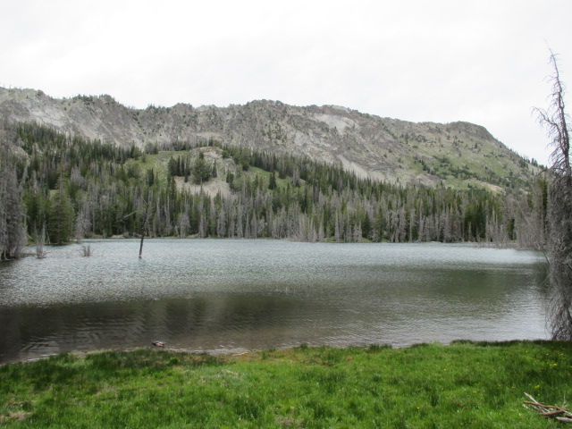
Prairie Lake.

We hit camp in 2 and a half hours, pumped water from the inlet, set up the tent and got to work on dinner.


We are somewhat fanatical about eating well outside.  For this trip, we did chicken quesadilla's.  No dehydrated meal's.  We prepped, planned and had super delicious food.

Deez approves of my concoction.

If there had been other people at the lake, they would have been drooling.

Chicken Quesadilla's.
Melting cheese on a tortilla is fairly self explanatory.  I won't give up my recipe or method for the Mexican Chicken Rice, but I will say this; I used a freezer bag and the instant kind.  Wink-wink.

The deer were quite comfortable with us chilling in there habitat.

After dinner, we had a nice established fire pit at our camp site.  Since we didn't bring dog, we had visitor's that we normally wouldn't have. They came in quite close.  We laughed as they circled our camp several times.  After a nice camp fire session, we called it a night.  It was very warm throughout the night and into the next morning.


We didn't get up too early since we had a relatively short climb.  Deez had made Banana Bread the day before we left and that's what we had for breakfast.


Our new 4 person tent was very roomy for 3.

Prairie Creek Peak.  10,138ft.


Working our way up to the saddle wasn't too hard and we soon got a good look at our peak.

Castle Peak.

Shadow Peak on the left.

I finally got a decent view of Shadow Peak and Prairie Lake.


The west ridge of Peak 9863 didn't look too bad and our excitement grew more and more with each step we took.


From the saddle, the hiking was fairly pleasant and the obstacles were few.

The north point of 9863.

There are two high points on the ridge and from the view below, the more prominent of the two appears to be the point to the north, but the north and south points are equal in elevation per my altimeter and GPS data.  The USGS map also identifies the south point as the peak.

Prairie Creek Peak.

I really wanted to hit Prairie Creek Peak, but I was not going to take Ian up it, and I was not about to leave him alone.  It would have to wait for another day.

Looking up the West Ridge.

There are goat trails that criss-cross the ridge.  The steepest part is at the top where the occasional use of hands was needed to aid in balance through the fractured rock.

Ian getting his rest step on.  Decent form, I'd say.

I taught Ian all about rest stepping and pressure breathing.  Slow and steady!

Nearing the top of the West Ridge.

Nearing the summit, looking north.

After the climb up the west ridge from the saddle, the route turns north to the summit.

The summit is in view in the trees. 

We saw goat poop and no signs of previous human occupation.  The views off the ridge were awesome in every direction.

Pioneer Mountains.  DBE is on the left.

Summit view, looking south.

Looking back on our route, it was easy to appreciate this beautiful area. I had told Ian that there is usually cell service up here and if there was, we would call Grandma to tell her where we were.

Ian: Hey, I have service!

Me: Haha, I told you.  Put Grandma on speaker phone!

So that's what we did.

Summit view, looking west.

We did plenty of looking around to make sure there was no trash, etc. There was nothing except the rocks, goat poop and Pika's.  No goat's though, so that was kind of a bummer.

Summit view, looking north.

A short journey to the north point revealed no signs of previous human occupation and an equal elevation to the south point.  So we christened it Bronco Peak, and Gator Point.

The West Ridge from the summit.

The North Point.


Prairie Creek Peak looks steep and mean from this angle.

Norton Peak.

Looking north.

Prairie Lake.  Looking northeast toward the Boulder and White Cloud Peaks.

We Woo-hooed from the top and Deez later told us she could hear it. That's pretty cool!


Summit View, looking southwest.

Looking north.

Bronco Peak came from Ian's unwavering love of the Boise State Bronco's.  Gator Point is from Denise's love of her home town team, the Florida Gator's.  Keepin' the Blue and Orange alive!

I took a short video at the top.


Summit Selfie.  

Ian standing in front of the summit on descent.

The summit of Peak 9863, aka Bronco Peak.

We did not leave a cairn, register or summit marker of any kind.  All we took was pictures; all we left was footprints.

Looking down the West Ridge to the saddle.  The trail goes to the left.
Reversing our route down the ridge took a little time because it was steep and loose.  Ian did well and I offered pointers and advice when needed.

Ian actively trying not to smile. 

We joked and laughed our way down the ridge and back to camp.

Goat territory.
This is about as steep as it gets.  Kind of loose, kind of steep, really not that bad.

Prairie Lake from camp. 

 After some snacks and breaking camp, we settled on two things; The Wicked Spud for burgers and The Wrangler for milk shakes.  Heck yes!


Looking down the trail.

It was warm and monotonous work back down the trail to the car.  We had had the lake to ourselves, but we pasted several day hikers going in and out.

Water break about a mile from the trailhead.

It only took a couple of short breaks to keep the spirits and pace up.


My beer stash was just cold enough to drink while we changed clothes and re-sorted our gear.
The work was behind us and we were glad to be in the air conditioned car and heading for some grub. Peak 9863, aka Bronco Peak was a fun little peak and since we didn't see anything to suggest otherwise, I think we humbly made the first ascent.

Google Earth overview of the region.

There was often discussion about sore feet, sore legs, this sucks, etc and I just answered with an old Ed Veisters quote.  Pain is temporary; glory is forever. 

Happy Trails!

- Granola, out.

Wednesday, May 27, 2015

Garden Benchmark. May 24th, 2015.

Partners: Ketchum.

Stats: >14 miles. >5,000 feet elevation gain. Summit elevation 7,005 feet. Time to summit, 5 hours. 7:45 round trip.

Route: Parked at the South fork bridge on the Banks-Lowman highway, hiked the ridge to peak 3668. Continued the ridge to an unnamed road, followed the road to the summit.

Garden Benchmark on Lists of John. Peak 3668 on Lists of John. Splattski's Trip Report.

Gear notes: Standard day hiking kit.

View of the upper ridge to a false summit.

Garden Peak, or Garden Benchmark, as it is listed, is a relatively small peak in terms of its summit elevation of 7,005 feet.  The route that I took does put up big mountain stats and has a big mountain feel while hiking the ridge that sits between the south and middle forks of the Payette river.

I've been wanting to get out to the greater ranges, you know, climb a real mountain, but with the recent wild weather and loads of precipitation in the mountains, I felt it was probably a better idea to keep it low and close to home.  I still wanted the burly workout that comes with climbing big mountains, but I did not want to drive 3 hours to hike in the rain.

Banks is a 30 minute drive from my door step, so I had no reason to not pack my A game and give it a go.  The dog and I were parked at the bridge just a bit past 8am and were soon working up the steep hill side towards peak 3668 with mild temps, a light wind and a 30% chance of thunderstorms later in the day.

Looking over Banks and the south fork bridge parking area.

If you just wanted to get to Garden Benchmark, there are surely shorter ways.  One thing that drew me to this particular route is that it is a long ridge walk and was sure to provide great views the whole way.  It steeply gains elevation and right from the start the views are incredible.

Looking toward Peak 3668.

Peak 3668 is not far from the road, but due to the high mileage day that lay ahead, the standard slow-steady pace was mandatory.

The first views of the upper ridge are sobering.

After cresting the first peak, the upper ridge came into view.  It has a few significant up's and down's, and the end looked to be a long ways away.

Green grass and wild flowers.

Thanks to the recent heavy rain, the slopes were green and the wild flowers were blooming.  Not a bad day to be out!

Looking up the south fork of the Payette River.

The next two significant points along the ridge required some light scrambling, but I bypassed them because my dog likes to follow and sometimes he slips and almost takes me out.  He's a great partner, but kind of a sloppy scrambler.

Looking southwest, toward the start of the ridge.

After about 2 hours of hiking, I stopped for a short break in an area where the ridge is fairly mellow. While walking along the flat section, I heard a noise that I don't think I've actually heard in person before, but I knew exactly what it was.  Mr. Rattlesnake was letting us know that we were in his way, but he waited to do so until I dang near stepped on him.

The first Rattlesnake I've seen.

I was able to wrangle Ketchum and we backed well away.  I reviewed Rattlesnake bite protocol, which is pretty much just don't get bit, and we left Mr. Rattlesnake to do his Rattlesnake stuff.

Sorry to have disturbed you!


Looking at the top of the ridge.

Toward the top of the ridge is the steepest part and obviously reveals the best views.

View looking down the ridge.


Grazing sheep along the route.

There were sheep grazing on the upper slopes and I met a Peruvian Shepherd named Pablo; he's a nice guy.  It was from about here that an unnamed road heads toward the small saddle seen in the photo above.  Form the saddle, I knew that I could follow the road to the summit, or I could bushwhack across Eddy Creek for what seemed to be a shortcut.  I figured that running/hiking along the road would be quicker than the bushwhack, so that's what I did.  I was over 4 miles in at this point.

Garden Peak finally in view.

From that saddle, I also got my first legit view of the peak.  It appears rather unimpressive after such an awesome hike up the ridge.

Sign indicating Garden Saddle.

Keeping to the road was easy going and I was able to make good time.  Naturally, the last of the gain came at the end of the road.

View from Garden Benchmark.

After about 5 hours from leaving the car, we found the summit and the USGS benchmark.

Somehow, I found time to take a summit selfie while shoving food in my mouth. 
USGS marker.

Shaffer Butte.

After a short time exploring the immediate area, snapping some pictures and having lunch, I was ready to toss out my short foam pad and jacket and relax for a few.  Maybe even take a short nap.  No sooner had I finished eating and getting affairs in order for a chillax session, had I looked up to notice the could's now appeared to be rapidly growing and the wind had picked up.

Cumulonimbus.

Seriously, I just wanted to chill for a few.  Fair well Garden Peak, for we hardly knew ye... 

Knowing that this was likely the beginning of thunderstorms, I decided to pack up and head out.  If I still had some time before any lighting started, I wanted to be down off of the exposed upper slopes of the ridge.

Ketchum trotting along the road with Squaw Butte in the distance. 

After nearly 5 hours of continuous work, having my summit break cut short was a little disheartening. I was beginning to feel the wear and tear of the hike and there was a brief moment when I thought I might have gone a little too far and should just find a nice sheltered spot and hang for a few.  After I was already up and going, I fell back into my pace and just kept cruising back down the road to the saddle that holds the passage to the ridge.

View of the ridge taken below the corridor.

On the way out, I got about 5 minutes of hail and some intermittent sprinkles, but never did get any lightning or hear thunder.  Looking back down the ridge, I decided to cut off to the south about half way down, near the Rattlesnake sighting and walk the road instead of hauling up and over the high points on the ridge again.

Looking south over the river canyon.

That wasn't a terrible idea but the long down hill section was the hardest part of the day, then uneventful and boring along the road.  I was surprised that such a small peak so close to home could kick out stats that rival the bigger peaks, other than the summit elevation.  It's easy to say that this was one of the greater tests of endurance I've had in a while.  This hike was more about the physical and mental test and less about the peak itself.  I would also have to say that the spiritual and philosophical enlightenment that comes from great amounts of physical exertion is always worth it, no matter what the chosen medium may be.

Now, who wants to go climb some 12ers?

Happy trails!

- Granola, out.

Monday, May 18, 2015

Peak 4602 5-18-2015

Partners: Dog.

Stats: Distance 5.27 miles. Elevation Gain approx 2,000ft. Total time 2:30.

Route: From Highway 55 scenic overlook to pt 4114, to pt 4430, to Peak 4602 and a side trip to pt 4304. Topo Map Peak 4602 on Lists of John

Gear notes: Ended up bringing three jackets despite packing "light".

Peak 4602.

I've been looking at some peaks off of Hwy 55 since it is so close to my house and I haven't explored the area.  Peak 4602 caught my eye for this short trip because it sits on a long ridge that I decided to walk since it was sure to provide a great view of Horseshoe Bend.  It looks like Mark Jones made the first ascent of this peak on his list of peaks within one hour of Boise, at some point.  Peak 4602 sits on BLM land so I figured access shouldn't be too tough.

Dog and I hit the road about 10am and were parked at the scenic overlook on Hwy 55 about 15 minutes later.  Cloudy, fairly humid, temp 57F with light wind and an occasional rain drop.  The first goal was to run across Hwy 55 to get on route.  That in itself is a terrifying experience.

Mores Mountain on the left, Shaffer Butte on the right. 

Once across the highway, my route followed the steep hill side to point 4114 where we had to duck under a fence on BLM land.  Once past there I was treated to a fine view of near by Shaffer Butte and Mores Mountain.  Turing to the east to gain the next point brought up another fence we had to duck.

Approaching Peak 4602 along the ridge.

From point 4430, there is an old road that leads directly to peak 4602, so naturally, that's the way I went.

The actual summit of Peak 4602.

Once I was on top of what I thought was peak 4602, I realized that wasn't the highest point, so I headed a little farther to the east.  Once there, I found this bump on the ridge was about ten feet higher than the other little bump.  The odd thing is that the USGS map clearly identifies the elevation as 4602, but my altimeter, which was calibrated, read 4580 and the GPS on my phone indicated 4590 - somthingish. Hhmmm...  The other odd thing was that the GPS compass went all weird and wasn't indicating the correct heading.  I concluded these anomaly's are due to the large flat area of the summit actually being a UFO landing site used by Grey Aliens that probably come from Zeta Reticuli.  No actual science was done regarding this conclusion, its just a blind guess.

Ketchum on the flat summit.  Squaw Butte is in the background.

I was certain of where I was, but not certain why the elevations did not check.  Oh well...

A slightly confused summit photo.

Then it was on to point 4303 to finish off the whole ridge.  There is a big dip and the hike is steep on both sides, which made for a good time to run in boots with a pack on.

Point 4303 on the far end of the ridge.

The view over Horseshoe Bend was totally worth the effort to get there.

Horseshoe Bend from point 4303

From pt 4303, I simply reversed my steps, bypassing pt 4430 on the way back to the car.
This was a great opportunity to explore a different part of the foothills and it turned out to be a good workout as well.  In the end, I got in another lame-local peak, safely made two crossings of Hwy 55 and avoided alien abduction.  The next ascent party may not be so lucky.

Happy Trails!

- Granola, out.

Monday, May 4, 2015

Teapot Dome 5-03-2015

Partners: Deez and Landen (AKA Lego Master).

Stats: 3.5 miles. Total time, 3hrs. Elevation gain approx 1,000ft. Summit: 4,713.  Route: Hiked from the west end of the lower south ridge to the south slope and headed east to the summit.

Gear notes: N/A.

Dan Robbins' TR.   Lists of John data.

Teapot Dome.

Teapot dome is a small peak that consists mostly of igneous rocks and is oriented along an east to west trending ridge line.  It sits just off the Sun Valley Highway and is only a few miles north of Mountain Home.  I was actually saving this peak for some time while driving home from the greater ranges of Idaho, since I'd already be right there.  The summit can be attained via a very short walk from Teapot road and that in itself does not prompt a drive.  However, while looking over the map, I noticed 2 other peaks in the vicinity, so that was game on.

We left town a tad bit on the late side to make a real effort to hit all three peaks, but at least we would still have time to hike Teapot Dome. Heck, at least we weren't sitting at home, and I've been told that this hiking stuff is actually good for you.  The day was forecast to be fairly warm and it certainly was when we parked a little after 1pm.  We parked along the road at the western end of the peak to add some distance and extra ground to explore.

Short scrambles to be had along the way.

We found some neat outcrops to scramble over.

The true summit sits behind the high point seen here.

We followed the ridge line to the east, toward the actual peak, then turned north heading up a south facing gully.

The south gully.

The gully was steep but really not that bad.  It was warmer than we would have liked, but at least we were out.

Just shy of the summit ridge, the energy of the group was attenuating, so we stopped for a decent water break before the final push.

Summit of Teapot Dome.
From the break area, we turned our toes to the east and kept at it.
After another half mile or so, we crept up to the flat area that is the summit.

Summit cairn of Teapot Dome.
The sky was hazy and that left the view over the Snake River Plain rather limited.

Summit shot with Bennett Mountain in the background.

After signing the register and a quick summit selfie, we headed back to rejoin Denise.  After one more short break we made like sheep herder's and got the flock out of there.  The lack of shade made the upper 70 degree temps feel much warmer than that.  We made it back to the car and headed into town to sweeten the deal by grabbing a milk shake for the youngest explorer of the group.

Southern slopes of Teapot Dome.
One can save significant time and effort by driving farther down the road and hiking a more direct route to the top.  We made it harder on ourselves just for the LOL's and to offset the windshield time required to get there.

And that's a wrap sports fans!

Happy trails!

- Granola, out.