Tuesday, June 7, 2016

Mount Church

The north face snow climb up Mount Church is steep and remote.

Ascent date: June 3-4, 2016

Partners: Cody, Jim and Lerch.

Stats: 50 degree Snow climb, 4,300ft gain to 12,180ft and 9 miles in 22hrs round trip but didn't get the true summit.

Gear notes: Overnight bivy kit - approx 25lb packs.

Links: Summit attained in 2017Summitpost pageLists of JohnCody's GoPro footage.

Jim in front of Mt. Church.

Cody, Jim and I put together a climb up the north face of Idaho's third highest mountain. 12.200ft tall Mount Church is normally climbed from the west side and approached from highway 93. Cody and Jim wanted a ski descent so the north face was the logical choice for them and I've been eyeing this route for a long time myself. The drive to the Pashimori side is longer and significanly more rough than the highway making this route very remote. We saw a few people on the drive in and out, but had the mountain all to ourselves.


Lerch. Note: Cody is getting in the front-left passenger seat. Jim is in the drivers seat on the right.

Cody and I met Jim and his rig Lerch in Banks and set off on the long drive. Lerch is a trailhead finding beast of a machine with quite the back story. He was the superhero of the trip as Jim piloted us into the very rugged but amazingly beautiful Pashimori Valley. We ran into a guy from Virginia who reported he had attempted Mt. Corruption, only to be stopped short of the summit due to soft snow at about 11am.

Pashimori Valley.

Pashimori Valley.

Pashimori Valley,

We arrived at the trailhead and were packed up and rolling just after 5pm. We had a moderatley difficult cross-country approach to lake 9682 where we planned to bivy for a few short hours.

Heading out.

We hopped across the east fork and followed the trail for a short time before heading off-trail into the canyon.

Approaching the trail.

Jim and Cody carried skis so they did a majority of the route finding down low as we wandered and bushwhacked through the canyon.

Mt. Church.

Seeing the north face with my own eyes for the first time struck me pretty hard. Its very big and imposing to say the least.

Creek crossing.

First thing was next, find the bivy spot. We were able to find our landmarks and picked our way up the canyon without too much trouble. Then we saw this tall and beautiful waterfall that we were on the wrong side of. We hiked the scree and snow fields to the right and crossed above it where the river originates as a spring from the hillside.

Water fall.


Upper valley.

Once we got across the water hazard and above the treeline, the going was pretty smooth, but the hour was growing late. We needed a bivy site and preferably before dark.

Note the crack in the upper snow field.

This side of the Lost River Range has a wonderful alpine feel to it. The upper valley here is just spectacular.

Approaching camp.

Jim was below Cody and I when we came across a meadow with running water and was the first into our unplanned Shangri-La bivy site. We decided to hold up here and climb the rest in the morning


Bivy.


Sunrise.


The overnight temps never felt too low as I laid in my bivy sack while drifting in and out of consciousness. We were up at 04:30, fueled up, loaded our packs and were going an hour later. 

Hmm, it's kinda warm for snow climbing...

Mt. Church.

We were less than impressed with the snow as we started out. The quantity was there, just not the quality. I was on snow shoes moving up the unsuportive snow with some difficulty while Jim and Cody skinned up with what appeared to be relative ease.

Route up the north face.

We passed the lake that we had originally planned to bivy at. It was open and there was enough flat ground to camp. We all had to shed a layer pretty quick in the warm morning temps. The name of the game became top out by ten, done by one. We got a move on. The ledge's on the face lay cattywampus and with the soft and lousy snow, we chose the main snowfield to the left to avoid exposure to the cliffs that cross the fall line, in case of a slip and being unable to self arrest.

Jim and Cody skinning up the headwall.

Skinning up looked to be going well for Cody and Jim. I was sinking in to the boot top level with snow shoes on. Fun times. We could see a lot of recent wet slide activity as we worked up the headwall.

Old avy track.

We regrouped and applied crampons to climb up some old avy debris hoping it would be firm. It was not. The lack of supportive snow made for tough going and a suspision that we might not get too high before needing to bail.

Low on the north face.

We soldiered on taking only short maintenance breaks and taking turns breaking trail. We did see old ski and boot tracks in the snow.

Jim starting his lead.

The higher you go on the route, the more the angle increases.

Break time.

It was 8am and already t-shirt weather with a slight breeze.
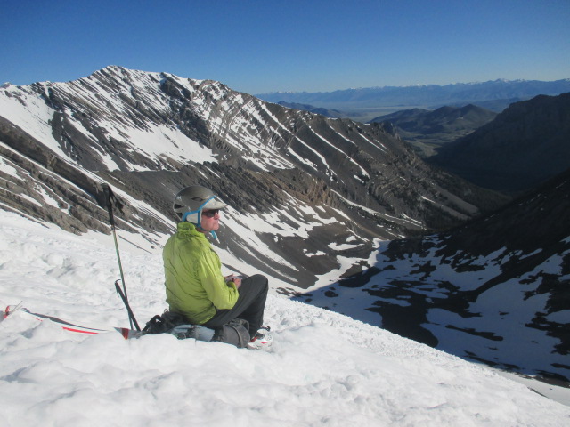
Jim at a rest break.

After Jim's lead, he and I had a short break while Cody pushed on.

Cody finishing his lead.

We caught up to Cody while he rested and then I took the lead for the last 1,400ft or so to the top of the north face. It was a difficult lead in the ever softening snow. I fought for every step.

Step, sink, stab, stab. Step, sink, stab, stab. Step, sink, stab, stab. Step, sink, stab, stab.

We estimated the upper slopes to be 50-plus degrees as we four pointed our way up. Once on top we saw the knife edge summit ridge was corniced and we couldn't go any farther. Perspective of the ridge was hard to tell but our summit was very airy with bearly enough room for the three of us. We did the typical well that point might be higher, yada-yada for about thirty seconds of the two minutes we spent on top.

All smiles on the top of the north face.

A few pictures and few sips of water was about all we had time for. It was 9:30 and we needed to get down ASAP.

High point.

Looks like we missed the actual highpoint by just a bit. My altimeter logged 12,180 which was probably off a bit one way or the other. I think Codys GPS said 12,155...? I suppose it was a near miss but we were elated that we climbed the north face. Jim and Cody felt it was close enough and I would agree, the high point was a technicality. I guess I'd say that we summited but did not hit the high point. The peak bagger in me still feels only 99.9% satsified.

Oh well, sometimes that's all you get!

Looking north towards Borah Peak.

I was more concerned with being stable on our small perch in the sky than I was with photos or high points. In hindsight, I'm a little disappointed I didn't get more photos of the gnarly ridge.

12k mildly hypoixic grin.

Jim enjoying the views.

We had the Idaho Summits Spring Outing group in our thoughts and hoped they were doing well as we gazed at the Pioneer Mountains. I started down while Cody and Jim clicked into their skis. They were well past me in no time and I struggled my way down. Normally, plunge stepping isn't that bad, but it's hard to do when you sink in up to your knees with every step.

Arch at the base of Mt. Church.

We regrouped at the bottom of the face and refueled once more before heading back to camp.

Lake 9682.

Cody and Jim heading down.

We broke camp and were heading down about a quarter past noon. Not bad, but we still had the off trail descent to do with full packs. It was slow going at times but we found a good route down the canyon and back to Lerch.

Mt. Church from the trail.

I will say that this trip had it all: It was remote with a moderately difficult cross-country approach, a cool bivy site, alpine start, crappy snow, difficult steep face to an airy summit with no time to spare on the route and with great partners who had PMA all the way. Per Cody and Jim, this was Type II fun; hard and kinda hate it while you're doing it, but remebered as fun in retrospect. 


Adventure level was 10/10 and we were all smiles as we headed back to civilization with Jim at the helm of Lerch for the long and bumpy drive out of the Pashimori Valley. This trip is easily on my favorite list.


Happy trails!

Monday, May 23, 2016

Boise Peak

Boise Peak is not the most scenic or desirable summit, but it's still a peak so here is what you need to know to go get it.

Ascent Date: 5/22/2016.

Partners: N/A.

Stats: Varies bases on the approach. This trip was a 17.8 mile trail run with 3,600 feet of gain. It can be done as a much shorter hike.

Gear notes: Mountain Hardwear Race Vest with 2 500ml collapsible water bottles, 2 packs of Shot Bloks, 2 packs of sesame/chocolate cookies and a light soft shell jacket.

Links: My stats and routeBoise Peak on Summitpost.orgBoise Peak on Idaho: A Climbing GuideLists of John data.

The current weather cycles have had me pined down on my days off, so I've been running more to keep up the training for Rainier and now a 30k trail race in September. I've never been accused of being fast, or smart, and this trip was neither of those. No pictures from this trip up. I used this peak to add some miles and elevation gain to my training runs in the foothills. To get to the actual highpoint involves off trail bushwhacking and there is literally no view to be had from the top. I had to dilly-dally with my GPS to find the highpoint because there were a few trails that appeared to lead to the top but they ended in dense brush. As I learned the hard way, just stay on the roads and at the very end, turn left to the top. I was being lazy and tried to short cut it. This peak looks cool from the Treasure Valley, but there is nothing to see from the top except the brush and trees. See Tom Lopez's page on Idaho: A Climbing Guide for an accurate account of this peak - "I consider this hike a “check the box” type hike – it’s not super enjoyable or rewarding, but I needed to do it ONCE."

Photo: mtybumpo via Summitpost.org.

Happy trails!

Thursday, May 5, 2016

Grandjean Overnighter

Our anual early season overnight hike in the Grandjean area is a chill mini trip to kick off the season.

April 30 - May 1, 2016.

Partners: Deez.

Stats: Approx 5 mile round. Camp at Baron Creek.

Gear notes: Standard overnight kit.

Grandjean in the years past: 201320142015.

Western edge of the Sawtooths from the road. Photo: Denise Savoy.

A few years ago, we got a wild hair and decided to do an overnight hike out of Grandjean. It was April and a low snow year so we were good to go. We went for it the next two years and have since decided that we no longer consider it a teaser trip. It is now the annual Grandjean kickoff trip. After 4 times and counting, we have camped at a different site each time. Its a short and easy hike to Baron Creek, which has a host of good camp sites, so it is doable even if you leave town late.

We started out from the trail head about 4:30pm under cloudy skies and warm temps. The weather forecast gave a 30% chance of precip, so we were prepared for the worst and headed out for 100% fun.

Trailhead goofballs.

This trip gets categorized as easy; the stress factor is as low as the mileage.

South Fork Payette River Trail.

The area had melted out nicely and we explored off trail a bit. Even though we had plenty of time and could have easily walked farther, we stopped at Baron Creek and found a splendid camp site west of the trail.

Camp along side Baron Creek.

Only a few small patches of snow lingered and the ground was dry, so we had no difficulty finding a spot to pitch the tent. I had a loose plan of climbing Grandjean Peak the following morning, but after distant observation, I decided that the creek would be too difficult to cross and there was more snow than would be safe for the class 3 scramble to the top.

Maybe some other time.

The DiMaggio never tasted so good.

We take this trip nice and easy; we don't even cook dinner. It was gourmet Italian sandwiches for us.

Camp.

Getting into camp after just over an hour of walking gave us lots of time to relax; just what we had came for.

In camp. Photo: Denise Savoy.

Hey, lets have some drinks and take some pictures!


Evening sky. Photo: Denise Savoy.


The cloud cover broke up and we were gawking at the stars before it was dark enough for headlamps.

Fire.

We sipped our drinks and got our groove on while the music played. As usual on the Grandjean trip, it was later than I'll admit when we decided it was time for bed. The next morning was crystal clear and warm. With only a short walk back to the car, we got up and rolling at a lazy hour.


Morning at Baron Creek.

We broke camp and unhurriedly headed down the trail. Short and easy was the name of the game. Too bad the weather was so nice. We would have rather headed to the next camp site instead of having to go back home and return to adulting.


Grandjean Peak west summit.

With the big trips coming up soon, we enjoyed the chill that is our annual Grandjean outing.


Hike out.

Best pun ever: Hey, did I tell you about the backpacking trip I just did? Yeah, the hike was fun and the camping was in-tents.

Happy trails! Granola, out.

Wednesday, April 20, 2016

Second Peak. April 17, 2016

A training hike leads to my first trip in the Soldier Mountains.

Partners: Deb and Brett (Ex Flatlander).

Stats: Class 2 snow. 3,500ft gain to summit elevation 9,529. 10.25 miles and 8 hours round trip.

Gear notes: Carried snow shoes, crampons and ice ax; never used them.

Links: Lists of JohnIdaho Summits Soldier Mountains overview pageIdaho Summits trip reportSplattski's trip report.

Second Peak.

Spring time is a surprisingly hard time to climb bigger peaks. The snow melt typically means access gets better and routes get safer. However, the changing conditions are always a factor. How soon is too soon? How late is too late?  Spring time energy and a need to train means over exuberance when it comes to choosing objectives. Since spring is still considered a shoulder season, all the extra snow gear must be carried, such as snow shoes, crampons and ice ax's even though it might not get used.

I was wanting to get the high point of the Soldier Range, 10,095 foot tall Smoky Dome. I was eyeing a system of ridges that connects North Smoky Dome, Smoky Dome, 3rd and 2nd Peaks. Over exuberant; yes. Doable; I had no clue. I had planned to drive as far past the ski area as I could and start from the north. It turned out that the road shown on the map was in fact a trail. I was really hoping, and the planned route depended on driving about 2.5 miles farther than was possible. Our new starting point meant we were adding about 5 more miles to whatever else the day had in store for us.

After the creek crossing, gaining the ridge.

We left the car at 8:00am sharp. I felt slightly disappointed about the added extra mileage but then I remembered that any training is good training; now there would be a lot of it. Objectives of the day were simple: positive vibes, stay safe and get as many peaks as we could. Spring climbing can be tough and summits are often hard to get.

Hiking.

So after the initial 2.5 mile hike down the trail, which burned precious time, we had to do Deb's favorite thing and cross a raging creek. That also burned  more time. By the time we were finally across the creek and headed up the ridge I had planned to descend, it was 10:30am. Time to move!

Hyndman, Old hyndman and Cobb.

Once we started the actual climb up to Second Peak, the view did not take long to slow us down. To clarify, I wanted to ascent the ridge to N. Smoky and descent off Second Peak. We discussed and felt it was more efficient to just stay on the ridge we were already on.

Proposed route.
The Google Earth image should explain my proposed route.


High on the ridge.

Slow is fast in the mountains, so we usually maintain the slow and steady pace to not burn out too early in the day. Brett is just plain fast so it didn't take him long to leap out in front.

Nearing 8,600ft.

The snow was in good shape and supporting our weight without snow shoes. I guess we'll just have extra training weight.

Just a few more feet to go.

Once we were past the steep part of the slope and out of the trees, we got a good view of the parallel ridge that would have been our descent route from North Smoky Dome.

Ridge of off N. Smoky Dome.

Enough about that ridge. We'll get to that later. First thing's first, we gotta get up Second Peak.


Last steps of the northeast ridge.

I did a poor job of hydrating and getting enough rest the day before, so I was feeling sluggish and slow on the final push up to Second Peak.

Second Peak weather station.

We topped out at 12:45 and elected to take a 15 minute break, our second of the day, before going to Third Peak. We quickly munched and drank while taking pictures.

Summit of Second Peak.

After a few hours of hard work, it was nice to finally feel like we had gotten somewhere. Time was ticking and we needed to get moving if we wanted to get Third Peak and Smoky Dome. We decided that the connecting ridge to N. Smoky would require a closer evaluation, but we could see overhanging cornices from Second Peak.

Summit view.

We geared up and headed down 2nd and headed for 3rd knowing that if we didn't go over to N. Smoky, we would have to reclimb 2nd and 3rd to get down.

Summit view.

As the saying goes; you don't know until you go. We decided to go for it.

3rd Peak on the left, Smoky Dome in the center, N. Smoky Dome on the right.

This route would be quite simple with less snow. With the ever softening snow and the hour growing late, the effort to do it was increasing.

Headed down 2nd Peak.

We were down 2nd and starting up 3rd when we decided it was simply going to take too long and be too much work to get up 3rd, let alone Smoky Dome, back up and down both peaks then and back down to the creek crossing. 

3rd Peak.

Considering the potential for wet slide avalanches, we pulled the plug. There was still a lot of distance to cover just to get back to the creek.

N. Smoky Dome.

We trudged back up to 2nd for a lunch break. After all, that was all we really came to do right? Walk uphill for a long time with a heavy pack, right?

Looking North.

Lunch with a view is always welcomed but I was still feeling lousy and ate what little I could. Soon we were heading down and the postholing began. We stuck to the trees where we could for the shade and firm snow, but I still punched though down to my knees a few times. On one thigh deep plunge, my leg instantly seized and I got to enjoy a fairly pervasive leg cramp, unlike anything I've had in a good long while. It lasted about thirty minutes longer than I would have liked.

On descent.

We reversed the ridge of ascent back to meet up with Deb's nemesis, the raging creek. Brett, being the turbo machine he is, was across it before Deb and I were even ready. I scooted across the log and Deb followed.

Creek crossing.

We all managed to stay dry and the raging creek soon became an afterthought while we endured the slushy and hot hike out. Somehow, the 2.5 miles of trail from the creek crossing to the car turned into 7 on the way out. Or at least that's what it felt like.

I can smell the car! we're getting close!

Soldier Mountains.

For being the first time I've ever poked my head into the Soldier Mountains, I think its easy to say that it's hard to beat. It's two hours away to a beautiful area with several fine peaks to be had. I think we fulfilled the training mission since we did 3,500 feet of gain with all that extra weight. I got a good first hand view and lots of pictures for beta.

Summit or no summit, training is still money in the bank.

Happy trails! Granola, out.